Súbor:Klimagürtel-der-erde-gemäßigte-zone.png

Veľkosť tohto náhľadu: 800 × 400 pixelov. Iné rozlíšenia: 320 × 160 pixelov | 640 × 320 pixelov | 1 024 × 512 pixelov | 1 280 × 640 pixelov | 3 600 × 1 800 pixelov .
Pôvodný súbor (3 600 × 1 800 pixelov, veľkosť súboru: 726 KB, MIME typ: image/png)
Zhrnutie
| Popis |
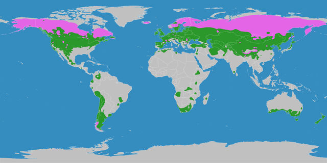
English: This map shows the Earth zones with a temperate climate.
Cold temperate (boreal) climate
Warm temperate climate
Deutsch: Diese Karte stellt die gemäßigte Klimazone der Erde dar.
Kaltgemäßigtes (boreales) Klima
Warmgemäßigtes Klima |
| Dátum | |
| Zdroj |
English: Own work on the basis of the following data: Deutsch: Selbst erstellt auf Basis dieser Geodaten:
|
| Autor | LordToran |
| Povolenie (Využívanie tohto súboru) |
|
| Ďalšie verzie |
 |
Licencovanie
Tento súbor podlieha licencii Creative Commons Attribution-Share Alike 3.0 Unported
- Môžete slobodne:
- zdieľať – kopírovať, šíriť a prenášať dielo
- meniť ho – upravovať dielo
- Za nasledovných podmienok:
- uvedenie autorov – Musíte spomenúť autorov (jednotlivo alebo kolektívne), poskytnúť odkaz na licenciu a uviesť, či ste niečo zmenili. Môžete to urobiť ľubovoľným primeraným spôsobom, ale nie spôsobom naznačujúcim, že poskytovateľ licencie podporuje vás alebo vaše použitie diela.
- meniť za rovnakých podmienok – Ak toto dielo zmeníte, prevediete do inej formy alebo použijete ako základ iného diela, musíte výsledok šíriť pod rovnakou alebo kompatibilnou licenciou ako originál.
História súboru
Po kliknutí na dátum/čas uvidíte ako súbor vyzeral vtedy.
| Dátum/Čas | Náhľad | Rozmery | Používateľ | Komentár | |
|---|---|---|---|---|---|
| aktuálna | 21:06, 11. október 2016 | | 3 600 × 1 800 (726 KB) | Maphobbyist | The Caspian Sea was omitted. The Köppen system is based on the concept that climate types are correlated with the natural vegetation. |
| 15:15, 15. október 2007 |  | 3 600 × 1 800 (626 KB) | Lortordermur | ||
| 20:43, 5. jún 2007 |  | 3 445 × 1 731 (664 KB) | Lortordermur | == Beschreibung == {{Information |Description=Diese Karte stellt die gemäßigte Klimazone der Erde dar. {{legend|#e465e6|Kaltgemäßigtes (boreales) Klima}} {{legend|#2a982a|Warmgemäßigtes Klima}} |Source=Selbst erstellt auf Basis [http://www.copern |
Použitie súboru
Na tento súbor odkazujú nasledujúce 2 stránky:
Globálne využitie súborov
Nasledovné ďalšie wiki používajú tento súbor:
- Použitie na el.wikipedia.org
- Použitie na hak.wikipedia.org
- Použitie na hu.wikipedia.org
- Použitie na nn.wikipedia.org
- Použitie na sw.wikipedia.org
- Použitie na vi.wikipedia.org