Súbor:LocationComoros.png
Nie je dostupné vyššie rozlíšenie.
LocationComoros.png (250 × 119 pixelov, veľkosť súboru: 5 KB, MIME typ: image/png)
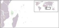
Locator map for the Comoros.
Originally created for English Wikipedia by Vardion.
| |
Uživatel Vardion z projektu v jazyce {{{6}}}, autor tohoto díla, jej uvolnil jako volné dílo, a to celosvětově. Není-li to podle zákona možné: |

|
K tomuto obrázku existuje vektorová verzia (v SVG).
Ak je lepšia, používajte radšej tú. File:LocationComoros.png → File:LocationComoros.svg
Podrobnejšie informácie o vektorovej grafike nájdete na stránke Commons:Transition to SVG. Taktiež si môžete prečítať informácie o podpore formátu SVG v MediaWiki. |
 |
História súboru
Po kliknutí na dátum/čas uvidíte ako súbor vyzeral vtedy.
| Dátum/Čas | Náhľad | Rozmery | Používateľ | Komentár | |
|---|---|---|---|---|---|
| aktuálna | 14:22, 5. marec 2008 | | 250 × 119 (5 KB) | Panos84 | Location of the island nation of Comoros and its exclusive economic zone. |
| 23:00, 11. december 2004 |  | 250 × 115 (6 KB) | EugeneZelenko | Location map for the Comoros.<br/>Originally created for English Wikipedia by Vardion.<br/>{{PD}}<br/>Category:Country locator maps |
Použitie súboru
Na tento súbor odkazuje nasledujúca stránka:
Globálne využitie súborov
Nasledovné ďalšie wiki používajú tento súbor:
- Použitie na ar.wikipedia.org
- Použitie na bg.wikipedia.org
- Použitie na bpy.wikipedia.org
- Použitie na bs.wikipedia.org
- Použitie na ceb.wikipedia.org
- Použitie na de.wikinews.org
- Použitie na de.wiktionary.org
- Použitie na en.wikipedia.org
- Použitie na en.wikivoyage.org
- Použitie na en.wiktionary.org
- Použitie na eo.wikipedia.org
- Použitie na es.wikipedia.org
- Použitie na eu.wiktionary.org
- Použitie na frp.wikipedia.org
- Použitie na fr.wikipedia.org
- Použitie na fr.wiktionary.org
- Použitie na he.wikivoyage.org
- Použitie na hif.wikipedia.org
- Použitie na hr.wiktionary.org
- Použitie na hu.wikipedia.org
Zobraziť ďalšie globálne použitie tohto súboru.