Súbor:Nangarhar districts.png
Veľkosť tohto náhľadu: 786 × 600 pixelov. Iné rozlíšenia: 315 × 240 pixelov | 629 × 480 pixelov | 1 000 × 763 pixelov .
Pôvodný súbor (1 000 × 763 pixelov, veľkosť súboru: 43 KB, MIME typ: image/png)

|
Tento obrázek (skupina map) by měl být vytvořen pomocí vektorové grafiky jako SVG soubor. To má několik výhod; podrobnosti najdete na stránce Commons:Media for cleanup. Je-li SVG verze tohoto obrázku již k dispozici, prosím nahrajte ji. Po nahrání nahraďte tuto šablonu šablonou {{Vector version available|jméno nového obrázku.svg}}.
|
Zhrnutie
| Popis |
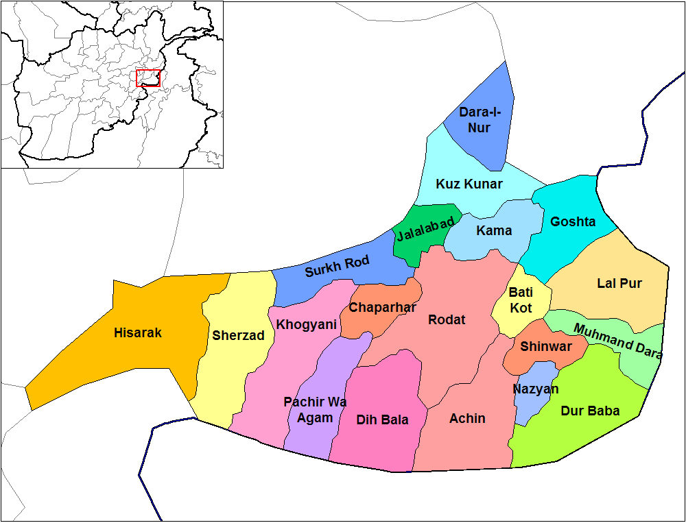
English: Map of the districts of Nangarhar province of Afghanistan. Created by Rarelibra 19:29, 29 March 2007 (UTC) for public domain use, using MapInfo Professional v8.5 and various mapping resources. |
| Dátum | 29. marca 2007 (datum prvotního načtení souboru) |
| Zdroj | No machine-readable source provided. Own work assumed (based on copyright claims). |
| Autor | No machine-readable author provided. Rarelibra assumed (based on copyright claims). |
Licencovanie
| Ja, držiteľ autorských práv k tomuto dielu, uvoľňujem toto dielo ako voľné dielo (public domain). Toto platí celosvetovo. V niektorých krajinách to zákon neumožňuje; v tom prípade: Udeľujem komukoľvek právo používať toto dielo na ľubovoľné účely, bez akýchkoľvek podmienok ak také podmienky nevyžaduje zákon. |
História súboru
Po kliknutí na dátum/čas uvidíte ako súbor vyzeral vtedy.
| Dátum/Čas | Náhľad | Rozmery | Používateľ | Komentár | |
|---|---|---|---|---|---|
| aktuálna | 14:32, 15. február 2024 | | 1 000 × 763 (43 KB) | User-duck | Cropped 5 % horizontally, 6 % vertically using CropTool with lossless mode. |
| 14:31, 15. február 2024 |  | 1 056 × 816 (43 KB) | User-duck | Reverted to version as of 19:29, 29 March 2007 (UTC)recrop | |
| 19:11, 14. február 2024 |  | 1 000 × 760 (43 KB) | User-duck | Cropped 5 % horizontally, 7 % vertically using CropTool with lossless mode. | |
| 19:29, 29. marec 2007 |  | 1 056 × 816 (43 KB) | Rarelibra | Map of the districts of Nangarhar province of Afghanistan. Created by ~~~~ for public domain use, using MapInfo Professional v8.5 and various mapping resources. |
Použitie súboru
Na tento súbor odkazuje nasledujúca stránka:
Globálne využitie súborov
Nasledovné ďalšie wiki používajú tento súbor:
- Použitie na ar.wikipedia.org
- Použitie na bn.wikipedia.org
- Použitie na ca.wikipedia.org
- Použitie na cs.wikipedia.org
- Použitie na de.wikipedia.org
- Použitie na en.wikipedia.org
- Nangarhar Province
- Districts of Afghanistan
- Haji Ghalib
- Achin District
- Bati Kot District
- Chaparhar District
- Darai Nur District
- Dur Baba District
- Goshta District
- Hesarak District
- Kama District
- Khogyani District
- Kuz Kunar District
- Lal Pur District
- Momand Dara District
- Nazyan District
- Pachir Aw Agam District
- Rodat District
- Sherzad District
- User talk:Rarelibra/Maps1
- Haska Meyna District
- Khogyani (Pashtun tribe)
- Kot District
- Haska Meyna
- Battle of Tora Bora (2017)
Zobraziť ďalšie globálne použitie tohto súboru.