Súbor:Peel map pd.png

Veľkosť tohto náhľadu: 313 × 599 pixelov. Iné rozlíšenia: 125 × 240 pixelov | 250 × 480 pixelov | 401 × 768 pixelov | 1 100 × 2 106 pixelov .
Pôvodný súbor (1 100 × 2 106 pixelov, veľkosť súboru: 341 KB, MIME typ: image/png)
| Popis |
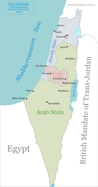
English: Map of the Peel Commission partition proposal for Palestine, 1937.
|
||
| Dátum | |||
| Zdroj | Vlastné dielo | ||
| Autor | Ynhockey | ||
| Povolenie (Využívanie tohto súboru) |
|
História súboru
Po kliknutí na dátum/čas uvidíte ako súbor vyzeral vtedy.
| Dátum/Čas | Náhľad | Rozmery | Používateľ | Komentár | |
|---|---|---|---|---|---|
| aktuálna | 13:42, 4. január 2009 | | 1 100 × 2 106 (341 KB) | Ynhockey | Correction - Tel Aviv was actually in the Jewish state. I thought it was weird, but only now found a map confirming it. |
| 09:51, 14. august 2006 |  | 1 097 × 2 100 (336 KB) | Ynhockey | Added Nazareth enclave, corrected status from 'International Zone' to 'Mandated Territory'. | |
| 18:28, 13. august 2006 |  | 1 097 × 2 100 (331 KB) | Ynhockey | Map of the Peel Commission partition proposal for Palestine, 1937. *Green - proposed Arab state *Blue - proposed Jewish state *Pink - proposed international neutral zone {{PD-self}} |
Použitie súboru
Na tento súbor odkazuje nasledujúca stránka:
Globálne využitie súborov
Nasledovné ďalšie wiki používajú tento súbor:
- Použitie na ar.wikipedia.org
- Použitie na ca.wikipedia.org
- Použitie na cs.wikipedia.org
- Použitie na da.wikipedia.org
- Použitie na en.wikipedia.org
- Použitie na eo.wikipedia.org
- Použitie na fi.wikipedia.org
- Použitie na fr.wikipedia.org
- Použitie na he.wikipedia.org
- Použitie na it.wikipedia.org
- Použitie na ja.wikipedia.org
- Použitie na ru.wikipedia.org
- Použitie na sq.wikipedia.org
- Použitie na uk.wikipedia.org
- Použitie na yi.wikipedia.org