Súbor:Volcanoes of Western Isabela.jpg
Nie je dostupné vyššie rozlíšenie.
Volcanoes_of_Western_Isabela.jpg (631 × 480 pixelov, veľkosť súboru: 99 KB, MIME typ: image/jpeg)
Zhrnutie
| Popis |
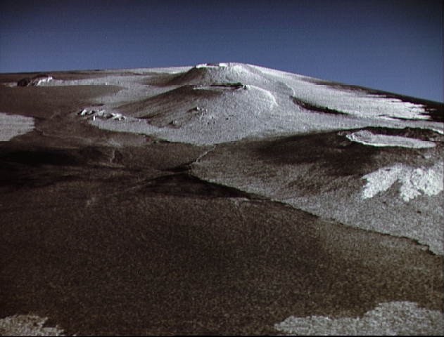
English: This is a three dimensional perspective view of Isla Isabela in the western Galapagos Islands. It was taken by the L-band radar in HH polarization from the Spaceborne Imaging Radar-C/X-Band Synthetic Aperature Radar on the 40th orbit of the Shuttle Endeavour. This view was constructed by overlaying a SIR-C radar image on a U.S. Geological Survey digital elevation map. The image is centered at about .5 degrees south latitude and 91 degrees West longitude and covers an area of 75 km by 60 km. This SIR-C/X-SAR image of Alcedo and Sierra Negra volcanoes shows the rougher lava flows as bright features, while ash deposits and smooth Pahoehoe lava flows dark. The Jet Propulsion Laboratory alternative photo number is P-43938. |
| Dátum | |
| Zdroj | www.nasaimages.org |
| Autor | NASA (Space Shuttle Endeavour) |
| Ďalšie verzie |
|


.jpg)
.jpg)
| Pozícia kamery | | Tento a ďalšie obrázky na: OpenStreetMap |
|---|
| Pozícia objektu | | Tento a ďalšie obrázky na: OpenStreetMap |
|---|
Licencovanie
| This file is in the public domain in the United States because it was solely created by NASA. NASA copyright policy states that "NASA material is not protected by copyright unless noted". (See Template:PD-USGov, NASA copyright policy page or JPL Image Use Policy.) | ||
 |
Warnings:
|
História súboru
Po kliknutí na dátum/čas uvidíte ako súbor vyzeral vtedy.
| Dátum/Čas | Náhľad | Rozmery | Používateľ | Komentár | |
|---|---|---|---|---|---|
| aktuálna | 21:36, 4. máj 2010 | | 631 × 480 (99 KB) | Dr Brains | {{Information |Description={{en|1=This is a three dimensional perspective view of Isla Isabela in the western Galapagos Islands. It was taken by the L-band radar in HH polarization from the Spaceborne Imaging Radar-C/X-Band Synthetic Aperature Radar on th |
Použitie súboru
Na tento súbor odkazuje nasledujúca stránka:
Globálne využitie súborov
Nasledovné ďalšie wiki používajú tento súbor:
- Použitie na cs.wikipedia.org
- Použitie na en.wikipedia.org
- Použitie na fr.wikipedia.org
- Použitie na it.wikipedia.org
- Použitie na ja.wikipedia.org