Súbor:Borders of the Historical Habsburgian Lands in the Republic of Slovenia.png

Veľkosť tohto náhľadu: 800 × 555 pixelov. Iné rozlíšenia: 320 × 222 pixelov | 640 × 444 pixelov | 919 × 637 pixelov .
Pôvodný súbor (919 × 637 pixelov, veľkosť súboru: 49 KB, MIME typ: image/png)

Zhrnutie
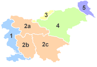
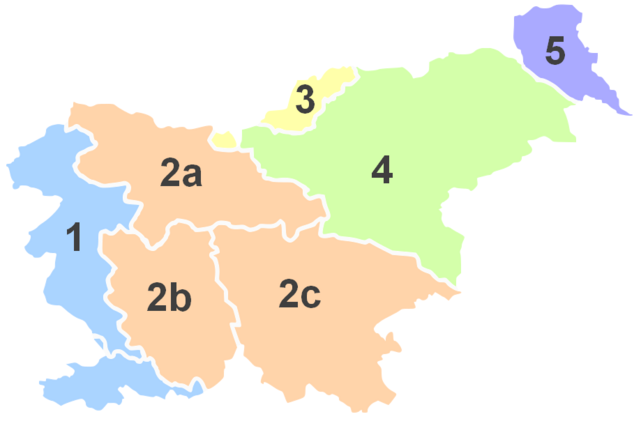
No. |
English |
||
| 1 | Littoral * | Primorska | Küstenland |
| 2 | Carniola | Kranjska | Krain |
| 2a | Upper Carniola | Gorenjska | Oberkrain |
| 2b | Inner Carniola | Notranjska | Innerkrain |
| 2c | Lower Carniola and White Carniola |
Dolenjska in Bela krajina |
Unterkrain und Weißkrain |
| 3 | Carinthia | Koroška | Kärnten |
| 4 | Styria | (Spodnja) Štajerska |
Untersteiermark |
| 5 | Prekmurje ** | Übermurgebiet ** | |
*Littoral used to be part of the historical Austrian Littoral.
**Prekmurje was not part of the historical Austrian crownland, but belonged to the Hungarian crown.

|
K tomuto obrázku existuje vektorová verzia (v SVG).
Ak je lepšia, používajte radšej tú. File:Borders of the Historical Habsburgian Lands in the Republic of Slovenia.png → File:Borders of the Historical Habsburgian Lands in the Republic of Slovenia.svg
Podrobnejšie informácie o vektorovej grafike nájdete na stránke Commons:Transition to SVG. Taktiež si môžete prečítať informácie o podpore formátu SVG v MediaWiki. |
 |
Licencovanie

|
Bolo udelené povolenie kopírovať, širiť a/alebo meniť tento dokument za podmienok GNU Free Documentation License, verzie 1.2 alebo ktorejkoľvek neskoršej verzie publikovanej Free Software Foundation; bez Nemenných častí, bez Textov na prednej obálke a bez Textov na zadnej obálke. Kópia tejto licencie je zahrnutá v časti nazvanej GNU Free Documentation License. |
| Tento súbor podlieha licencii Creative Commons Attribution-Share Alike 3.0 Unported | ||
| ||
| Táto šablóna licencie bola pridaná k tomuto súboru počas aktualizácie licencovania GFDL. |
História súboru
Po kliknutí na dátum/čas uvidíte ako súbor vyzeral vtedy.
| Dátum/Čas | Náhľad | Rozmery | Používateľ | Komentár | |
|---|---|---|---|---|---|
| aktuálna | 15:28, 18. december 2012 | | 919 × 637 (49 KB) | DancingPhilosopher | color |
| 15:24, 18. december 2012 |  | 919 × 637 (49 KB) | DancingPhilosopher | color | |
| 13:41, 17. december 2012 |  | 915 × 608 (46 KB) | DancingPhilosopher | Corrected boundaries | |
| 22:22, 19. júl 2005 |  | 400 × 289 (30 KB) | Besednjak~commonswiki | Austrian Crownlands in todays Slovenia. 1: Primorska/Küstenland, 2: Kranjsko/Krain (Carniola), 2a: Gorenjska/Oberkrain (Upper Carniola), 2b: Notranjska/Innerkrain (Inner Carniola), 2c: Dolenjska/Unterkrain (Lower Carniola), 3: Koroška/Kärnten (Carinthi |
Použitie súboru
Na tento súbor odkazuje nasledujúca stránka:
Globálne využitie súborov
Nasledovné ďalšie wiki používajú tento súbor:
- Použitie na an.wikipedia.org
- Použitie na ar.wikipedia.org
- Použitie na ast.wikipedia.org
- Použitie na be.wikipedia.org
- Použitie na br.wikipedia.org
- Použitie na ca.wikipedia.org
- Použitie na cs.wikipedia.org
- Použitie na cy.wikipedia.org
- Použitie na en.wikipedia.org
- Použitie na et.wikipedia.org
- Použitie na eu.wikipedia.org
- Použitie na fi.wikipedia.org
- Použitie na fr.wikipedia.org
Zobraziť ďalšie globálne použitie tohto súboru.