Súbor:British Empire in 1898.png

Veľkosť tohto náhľadu: 800 × 348 pixelov. Iné rozlíšenia: 320 × 139 pixelov | 640 × 278 pixelov | 1 434 × 624 pixelov .
Pôvodný súbor (1 434 × 624 pixelov, veľkosť súboru: 39 KB, MIME typ: image/png)

|
Tento obrázek (skupina map of the world) by měl být vytvořen pomocí vektorové grafiky jako SVG soubor. To má několik výhod; podrobnosti najdete na stránce Commons:Media for cleanup. Je-li SVG verze tohoto obrázku již k dispozici, prosím nahrajte ji. Po nahrání nahraďte tuto šablonu šablonou {{Vector version available|jméno nového obrázku.svg}}.
|
Zhrnutie
| Popis |
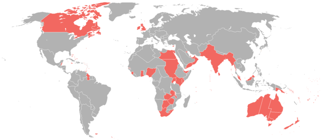
English: A map of the British Empire as it was in 1898, prior to the Second Boer War (1899-1902). |
| Dátum | |
| Zdroj | File:World_1898_empires_colonies_territory.png |
| Autor | User:Roke~commonswiki |
| Povolenie (Využívanie tohto súboru) |
File:World_1898_empires_colonies_territory.png |
Licencovanie
Tento súbor podlieha licencii Creative Commons Attribution-Share Alike 3.0 Unported
- Môžete slobodne:
- zdieľať – kopírovať, šíriť a prenášať dielo
- meniť ho – upravovať dielo
- Za nasledovných podmienok:
- uvedenie autorov – Musíte spomenúť autorov (jednotlivo alebo kolektívne), poskytnúť odkaz na licenciu a uviesť, či ste niečo zmenili. Môžete to urobiť ľubovoľným primeraným spôsobom, ale nie spôsobom naznačujúcim, že poskytovateľ licencie podporuje vás alebo vaše použitie diela.
- meniť za rovnakých podmienok – Ak toto dielo zmeníte, prevediete do inej formy alebo použijete ako základ iného diela, musíte výsledok šíriť pod rovnakou alebo kompatibilnou licenciou ako originál.
História súboru
Po kliknutí na dátum/čas uvidíte ako súbor vyzeral vtedy.
| Dátum/Čas | Náhľad | Rozmery | Používateľ | Komentár | |
|---|---|---|---|---|---|
| aktuálna | 08:08, 31. október 2021 | | 1 434 × 624 (39 KB) | Randomastwritter | jubaland |
| 23:12, 23. jún 2016 |  | 1 434 × 624 (31 KB) | Maproom | Islands near Madagascar, which were colored blue as French territory, now grey. | |
| 22:20, 11. apríl 2016 |  | 1 434 × 624 (38 KB) | The- | More accurate map | |
| 12:29, 7. júl 2015 |  | 1 357 × 628 (35 KB) | Snow Lion Fenian | {{subst:Upload marker added by en.wp UW}} {{Information |Description = {{en|A map of the British Empire as it was in 1898, prior to the Second Boer War (1899-1902).}} |Source = https://commons.wikimedia.org/wiki/File:World_1898_empires_colonies_territo... |
Použitie súboru
Na tento súbor odkazuje nasledujúca stránka:
Globálne využitie súborov
Nasledovné ďalšie wiki používajú tento súbor:
- Použitie na ar.wikipedia.org
- Použitie na ca.wikipedia.org
- Použitie na cs.wikipedia.org
- Použitie na de.wikipedia.org
- Použitie na en.wikipedia.org
- Použitie na es.wikipedia.org
- Použitie na et.wikipedia.org
- Použitie na ko.wikipedia.org
- Použitie na ta.wikipedia.org