Súbor:Buenos aires province numbered.png
Veľkosť tohto náhľadu: 434 × 599 pixelov. Iné rozlíšenia: 174 × 240 pixelov | 347 × 480 pixelov | 556 × 768 pixelov | 741 × 1 024 pixelov | 2 345 × 3 239 pixelov .
Pôvodný súbor (2 345 × 3 239 pixelov, veľkosť súboru: 9,37 MB, MIME typ: image/png)
Zhrnutie
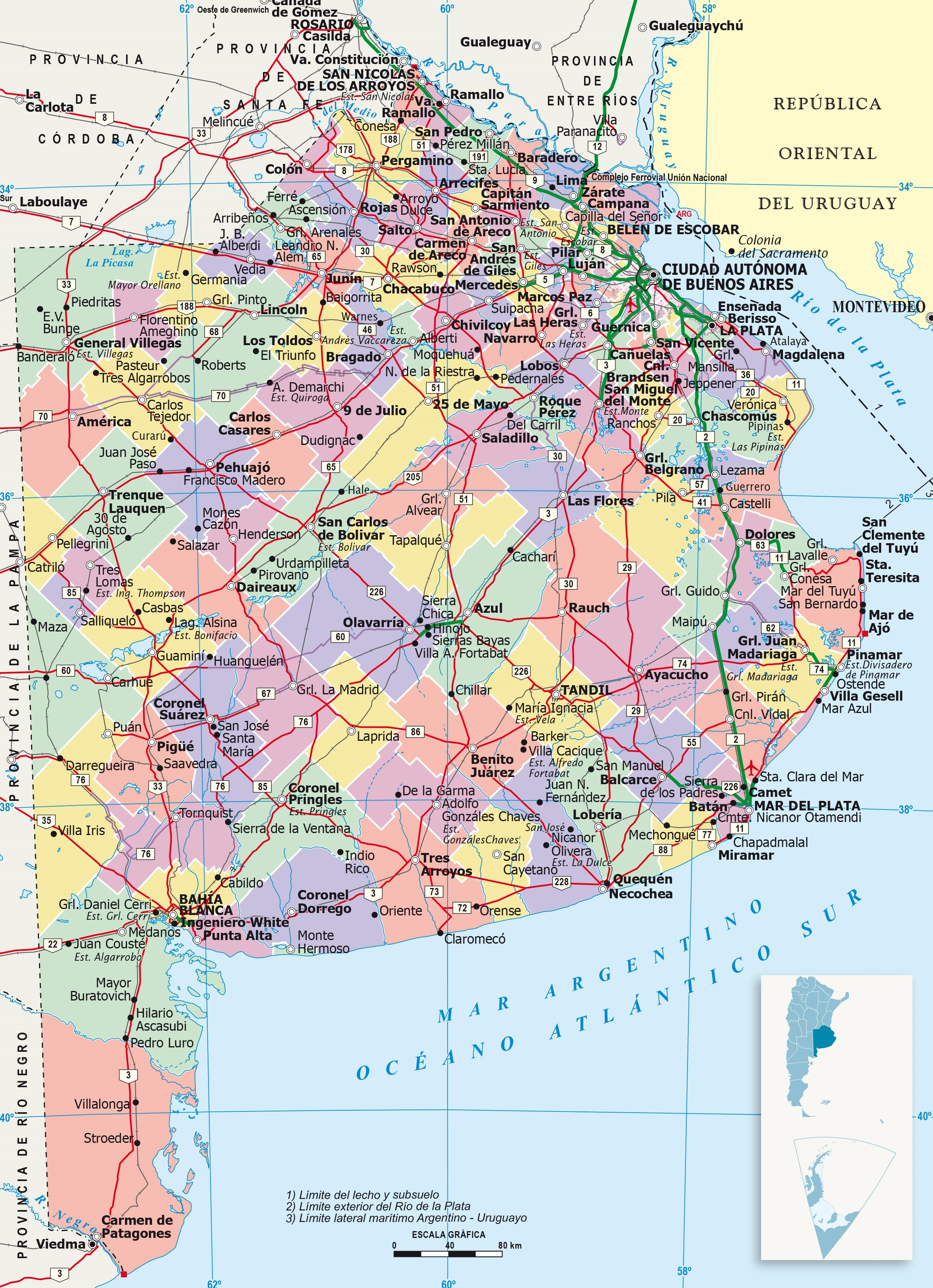
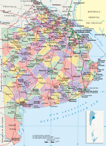
| Popis | It shows administrative division of Buenos Aires province, its capital (red point) and its boundaries. This version has reference numbers for easier locating of provinces. |
| Dátum | |
| Zdroj | https://www.ign.gob.ar/ |
| Autor | IGN (National Geographic Institute) |
Licencovanie
Tento soubor podléhá licenci Creative Commons Uveďte autora-Zachovejte licenci 4.0 International
- Môžete slobodne:
- zdieľať – kopírovať, šíriť a prenášať dielo
- meniť ho – upravovať dielo
- Za nasledovných podmienok:
- uvedenie autorov – Musíte spomenúť autorov (jednotlivo alebo kolektívne), poskytnúť odkaz na licenciu a uviesť, či ste niečo zmenili. Môžete to urobiť ľubovoľným primeraným spôsobom, ale nie spôsobom naznačujúcim, že poskytovateľ licencie podporuje vás alebo vaše použitie diela.
- meniť za rovnakých podmienok – Ak toto dielo zmeníte, prevediete do inej formy alebo použijete ako základ iného diela, musíte výsledok šíriť pod rovnakou alebo kompatibilnou licenciou ako originál.
Licencovanie
| Ja, držiteľ autorských práv k tomuto dielu, uvoľňujem toto dielo ako voľné dielo (public domain). Toto platí celosvetovo. V niektorých krajinách to zákon neumožňuje; v tom prípade: Udeľujem komukoľvek právo používať toto dielo na ľubovoľné účely, bez akýchkoľvek podmienok ak také podmienky nevyžaduje zákon. |
História súboru
Po kliknutí na dátum/čas uvidíte ako súbor vyzeral vtedy.
| Dátum/Čas | Náhľad | Rozmery | Používateľ | Komentár | |
|---|---|---|---|---|---|
| aktuálna | 04:45, 23. jún 2023 | | 2 345 × 3 239 (9,37 MB) | LibIchtnatz | Updated to a newer and clear version made by the IGN (National Geographic Institution) |
| 03:15, 31. august 2007 |  | 569 × 621 (36 KB) | Joshbaumgartner | == Summary == It shows administrative division of Buenos Aires province, its capital (red point) and its boundaries. This version has reference numbers for easier locating of provinces. == Licensing == {{PD-self}} [[Category:Maps of Buenos Aires Provinc |
Použitie súboru
Na tento súbor odkazuje nasledujúca stránka:
Globálne využitie súborov
Nasledovné ďalšie wiki používajú tento súbor:
- Použitie na cs.wikipedia.org
- Použitie na en.wikipedia.org
- Použitie na fa.wikipedia.org
- Použitie na fi.wikipedia.org
- Použitie na fr.wikipedia.org
- Použitie na hu.wikipedia.org
- Použitie na it.wikipedia.org
- Použitie na ja.wikipedia.org
- Použitie na ko.wikipedia.org
- Použitie na nds.wikipedia.org
- Použitie na tr.wikipedia.org
- Použitie na zh.wikipedia.org