Súbor:Democratic Republic of Georgia map.jpg
Veľkosť tohto náhľadu: 800 × 561 pixelov. Iné rozlíšenia: 320 × 224 pixelov | 640 × 448 pixelov | 1 024 × 718 pixelov | 1 213 × 850 pixelov .
Pôvodný súbor (1 213 × 850 pixelov, veľkosť súboru: 442 KB, MIME typ: image/jpeg)

|
Tento obrázek (skupina history map) by měl být vytvořen pomocí vektorové grafiky jako SVG soubor. To má několik výhod; podrobnosti najdete na stránce Commons:Media for cleanup. Je-li SVG verze tohoto obrázku již k dispozici, prosím nahrajte ji. Po nahrání nahraďte tuto šablonu šablonou {{Vector version available|jméno nového obrázku.svg}}.
|


Zhrnutie
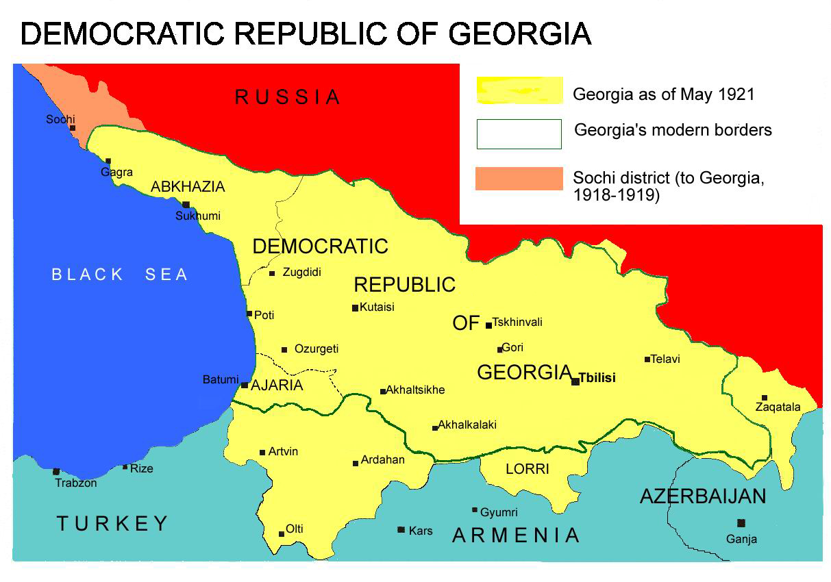
Democratic Republic of Georgia map, 1918-1921
Source: english wikipedia
Uploaded by user:Kober
Licencovanie
| Ja, držiteľ autorských práv k tomuto dielu, uvoľňujem toto dielo ako voľné dielo (public domain). Toto platí celosvetovo. V niektorých krajinách to zákon neumožňuje; v tom prípade: Udeľujem komukoľvek právo používať toto dielo na ľubovoľné účely, bez akýchkoľvek podmienok ak také podmienky nevyžaduje zákon. |
História súboru
Po kliknutí na dátum/čas uvidíte ako súbor vyzeral vtedy.
| Dátum/Čas | Náhľad | Rozmery | Používateľ | Komentár | |
|---|---|---|---|---|---|
| aktuálna | 13:26, 7. apríl 2013 | | 1 213 × 850 (442 KB) | Giorgi Balakhadze | At that time (May, 1921 year) there was no South Ossetia, it was created in 1922. |
| 13:21, 7. apríl 2013 |  | 1 213 × 850 (442 KB) | Giorgi Balakhadze | Reverted to version as of 13:08, 7 April 2013 | |
| 13:15, 7. apríl 2013 |  | 1 213 × 850 (442 KB) | Giorgi Balakhadze | At that time (1921 year) there was no South Ossetia, it was created 1922. | |
| 13:08, 7. apríl 2013 |  | 1 213 × 850 (442 KB) | Giorgi Balakhadze | At that time (1921 year) there was no South Osetia. | |
| 16:46, 26. december 2005 |  | 1 213 × 850 (111 KB) | Hardscarf | Democratic Republic of Georgia map, 1918-1921 Source: [http://en.wikipedia.org/wiki/Image:Democratic_Republic_of_Georgia_map.jpg english wikipedia] Uploaded by [http://en.wikipedia.org/wiki/User:Kober user:Kober] Category:Historical maps of Georgia |
Použitie súboru
Na tento súbor odkazuje nasledujúca stránka:
Globálne využitie súborov
Nasledovné ďalšie wiki používajú tento súbor:
- Použitie na bg.wikipedia.org
- Použitie na bn.wikipedia.org
- Použitie na da.wikipedia.org
- Použitie na de.wikipedia.org
- Použitie na en.wikipedia.org
- Použitie na en.wikibooks.org
- Použitie na fa.wikipedia.org
- Použitie na id.wikipedia.org
- Použitie na ka.wikipedia.org
- Použitie na lt.wikipedia.org
- Použitie na pl.wikipedia.org
- Použitie na pnb.wikipedia.org
- Použitie na pt.wikipedia.org
- Použitie na ru.wikipedia.org
- Použitie na sr.wikipedia.org
- Použitie na tr.wikipedia.org
- Použitie na uk.wikipedia.org
- Použitie na ur.wikipedia.org
- Použitie na zh.wikipedia.org