Súbor:Gabon location map.svg

Veľkosť tohoto PNG náhľadu tohoto SVG súboru: 646 × 600 pixelov. Iné rozlíšenia: 259 × 240 pixelov | 517 × 480 pixelov | 827 × 768 pixelov | 1 103 × 1 024 pixelov | 2 206 × 2 048 pixelov | 1 200 × 1 114 pixelov .
Pôvodný súbor (SVG súbor, 1 200 × 1 114 pixelov, veľkosť súboru: 206 KB)
Zhrnutie
| Popis |
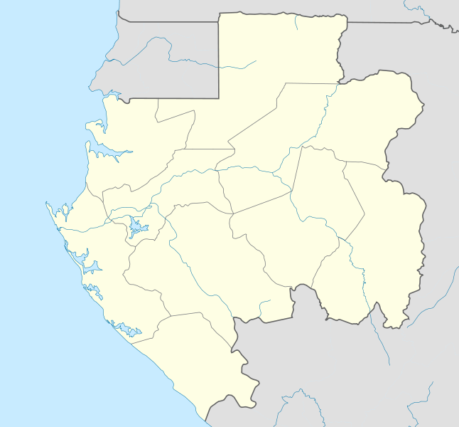
English: Location map of Gabon Equirectangular projection. Geographic limits of the map:
   * N: 2.5° N
   * S: 4° S
   * W: 8° E
   * E: 15° E
Made with Natural Earth. Free vector and raster map data @ naturalearthdata.com. |
| Dátum | |
| Zdroj | Vlastné dielo |
| Autor | Uwe Dedering |
| Ďalšie verzie |
Derivative works of this file: |
.svg)
.svg)
.svg)
.svg)
.svg)
.svg)
.svg)
.svg)
.svg)
Licencovanie
Ja, držiteľ autorských práv k tomuto dielu ho týmto zverejňujem za podmienok nasledovných licencií:
Tento súbor podlieha licencii Creative Commons Attribution-Share Alike 3.0 Unported
- Môžete slobodne:
- zdieľať – kopírovať, šíriť a prenášať dielo
- meniť ho – upravovať dielo
- Za nasledovných podmienok:
- uvedenie autorov – Musíte spomenúť autorov (jednotlivo alebo kolektívne), poskytnúť odkaz na licenciu a uviesť, či ste niečo zmenili. Môžete to urobiť ľubovoľným primeraným spôsobom, ale nie spôsobom naznačujúcim, že poskytovateľ licencie podporuje vás alebo vaše použitie diela.
- meniť za rovnakých podmienok – Ak toto dielo zmeníte, prevediete do inej formy alebo použijete ako základ iného diela, musíte výsledok šíriť pod rovnakou alebo kompatibilnou licenciou ako originál.

|
Bolo udelené povolenie kopírovať, širiť a/alebo meniť tento dokument za podmienok GNU Free Documentation License, verzie 1.2 alebo ktorejkoľvek neskoršej verzie publikovanej Free Software Foundation; bez Nemenných častí, bez Textov na prednej obálke a bez Textov na zadnej obálke. Kópia tejto licencie je zahrnutá v časti nazvanej GNU Free Documentation License. |
Môžete si zvoliť ľubovolnú z týchto licencií.
História súboru
Po kliknutí na dátum/čas uvidíte ako súbor vyzeral vtedy.
| Dátum/Čas | Náhľad | Rozmery | Používateľ | Komentár | |
|---|---|---|---|---|---|
| aktuálna | 19:27, 14. február 2010 | | 1 200 × 1 114 (206 KB) | Uwe Dedering | North: 2.5 |
| 19:14, 14. február 2010 |  | 1 200 × 1 200 (208 KB) | Uwe Dedering | {{Information |Description={{en|1=English: Location map of Gabon Equirectangular projection. Geographic limits of the map: * N: 3° N * S: 4° S * W: 8° E * E: 15° E - }} |Source={{own}} |Author=Uwe Dedering |Date |
Použitie súboru
Na tento súbor odkazujú nasledujúce 3 stránky:
Globálne využitie súborov
Nasledovné ďalšie wiki používajú tento súbor:
- Použitie na af.wikipedia.org
- Použitie na am.wikipedia.org
- Použitie na an.wikipedia.org
- Použitie na ar.wikipedia.org
- Použitie na ast.wikipedia.org
- Použitie na az.wikipedia.org
- Použitie na ba.wikipedia.org
- Použitie na be-tarask.wikipedia.org
- Použitie na be.wikipedia.org
- Použitie na bg.wikipedia.org
- Použitie na bn.wikipedia.org
- Použitie na bs.wikipedia.org
- Použitie na ca.wikipedia.org
- Použitie na ceb.wikipedia.org
Zobraziť ďalšie globálne použitie tohto súboru.