Súbor:Greece in 1210.svg

Veľkosť tohoto PNG náhľadu tohoto SVG súboru: 800 × 456 pixelov. Iné rozlíšenia: 320 × 182 pixelov | 640 × 365 pixelov | 1 024 × 584 pixelov | 1 280 × 730 pixelov | 2 560 × 1 460 pixelov | 3 508 × 2 000 pixelov .
Pôvodný súbor (SVG súbor, 3 508 × 2 000 pixelov, veľkosť súboru: 1,12 MB)
Zhrnutie
| Popis |
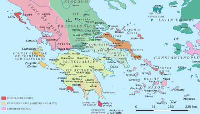
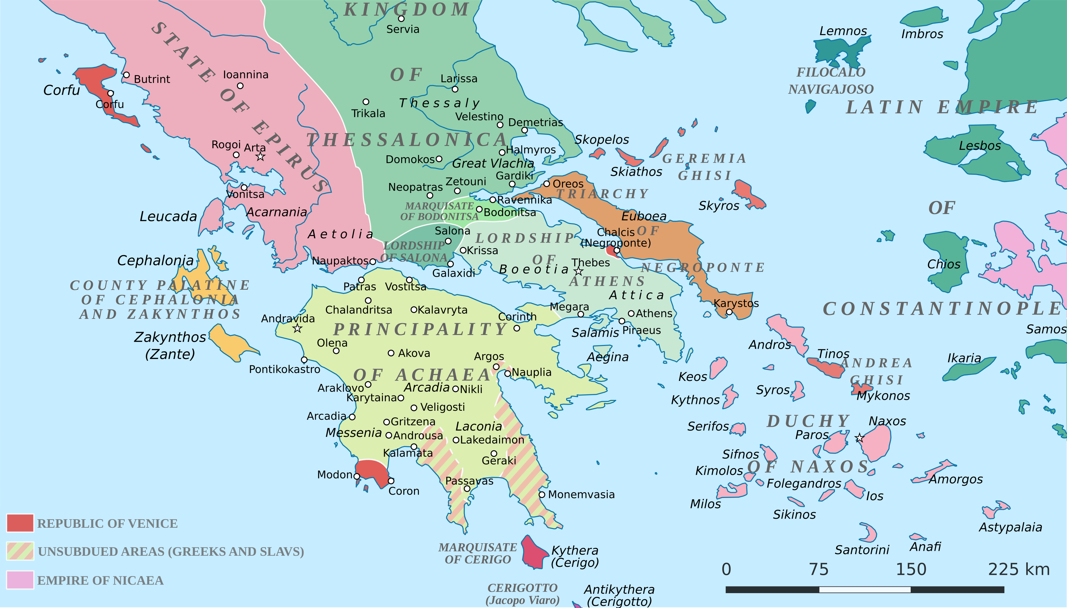
English: Political map of southern Greece in c. 1210, after the establishment of the Crusader states following the Fourth Crusade. |
| Dátum | |
| Zdroj |
SVG base from File:Greece in 1210V1.svg; based on the original political map by William Miller (1908), with changes and corrections to account for newer scholarship:
|
| Autor | Cplakidas |
| Ďalšie verzie |
|


Licencovanie
Ja, držiteľ autorských práv k tomuto dielu ho týmto zverejňujem za podmienok nasledovnej licencie:
Tento soubor podléhá licenci Creative Commons Uveďte autora-Zachovejte licenci 4.0 International
- Môžete slobodne:
- zdieľať – kopírovať, šíriť a prenášať dielo
- meniť ho – upravovať dielo
- Za nasledovných podmienok:
- uvedenie autorov – Musíte spomenúť autorov (jednotlivo alebo kolektívne), poskytnúť odkaz na licenciu a uviesť, či ste niečo zmenili. Môžete to urobiť ľubovoľným primeraným spôsobom, ale nie spôsobom naznačujúcim, že poskytovateľ licencie podporuje vás alebo vaše použitie diela.
- meniť za rovnakých podmienok – Ak toto dielo zmeníte, prevediete do inej formy alebo použijete ako základ iného diela, musíte výsledok šíriť pod rovnakou alebo kompatibilnou licenciou ako originál.
História súboru
Po kliknutí na dátum/čas uvidíte ako súbor vyzeral vtedy.
| Dátum/Čas | Náhľad | Rozmery | Používateľ | Komentár | |
|---|---|---|---|---|---|
| aktuálna | 19:59, 23. jún 2017 | | 3 508 × 2 000 (1,12 MB) | Cplakidas | fixed three names to paths |
| 12:08, 11. apríl 2017 |  | 3 508 × 2 000 (1,1 MB) | Cplakidas | colour changes | |
| 11:48, 11. apríl 2017 |  | 3 508 × 2 000 (1,11 MB) | Cplakidas | tweak around Coron | |
| 10:39, 11. február 2017 |  | 3 508 × 2 000 (1,11 MB) | Cplakidas | tweaks in Negroponte, unsubdued areas | |
| 17:57, 8. február 2017 |  | 3 508 × 2 000 (1,11 MB) | Cplakidas | tweaking the Morea | |
| 13:40, 8. február 2017 |  | 3 508 × 2 000 (1,11 MB) | Cplakidas | slight tweaks | |
| 13:14, 8. február 2017 |  | 3 508 × 2 000 (1,11 MB) | Cplakidas | User created page with UploadWizard |
Použitie súboru
Na tento súbor odkazuje nasledujúca stránka:
Globálne využitie súborov
Nasledovné ďalšie wiki používajú tento súbor:
- Použitie na ar.wikipedia.org
- Použitie na az.wikipedia.org
- Použitie na bg.wikipedia.org
- Použitie na ca.wikipedia.org
- Použitie na da.wikipedia.org
- Použitie na de.wikipedia.org
- Použitie na el.wikipedia.org
- Použitie na en.wikipedia.org
- Použitie na eo.wikipedia.org
- Použitie na eu.wikipedia.org
- Použitie na fa.wikipedia.org
- Použitie na fr.wikipedia.org
- Použitie na gl.wikipedia.org
- Použitie na hr.wikipedia.org
- Použitie na id.wikipedia.org
- Použitie na it.wikipedia.org
- Použitie na ja.wikipedia.org
- Použitie na ko.wikipedia.org
- Použitie na ro.wikipedia.org
- Použitie na ru.wikipedia.org
- Použitie na sr.wikipedia.org
Zobraziť ďalšie globálne použitie tohto súboru.