Súbor:Map Clervaux.png
Nie je dostupné vyššie rozlíšenie.
Map_Clervaux.png (203 × 270 pixelov, veľkosť súboru: 7 KB, MIME typ: image/png)
Zhrnutie
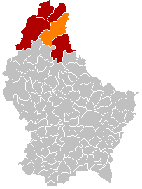
| Popis |
English: Clervaux municipality location after merging of municipalities (valid from 1 January 2012) |
| Dátum | |
| Zdroj |
English: Own edit of File:Map Clervaux.PNG |
| Autor | Les Meloures |
Licencovanie
| Ja, držiteľ autorských práv k tomuto dielu, uvoľňujem toto dielo ako voľné dielo (public domain). Toto platí celosvetovo. V niektorých krajinách to zákon neumožňuje; v tom prípade: Udeľujem komukoľvek právo používať toto dielo na ľubovoľné účely, bez akýchkoľvek podmienok ak také podmienky nevyžaduje zákon. |
História súboru
Po kliknutí na dátum/čas uvidíte ako súbor vyzeral vtedy.
| Dátum/Čas | Náhľad | Rozmery | Používateľ | Komentár | |
|---|---|---|---|---|---|
| aktuálna | 17:48, 8. január 2018 | | 203 × 270 (7 KB) | NordNordWest | corr |
| 17:27, 8. január 2018 |  | 203 × 270 (5 KB) | NordNordWest | upd | |
| 20:57, 10. november 2015 |  | 203 × 270 (5 KB) | NordNordWest | no more districts in Luxembourg | |
| 18:52, 27. október 2011 |  | 203 × 270 (3 KB) | Les Meloures | New map after changes in municipalities in Luxembourg | |
| 18:40, 27. október 2011 |  | 203 × 270 (3 KB) | Les Meloures | {{Information |Description ={{en|1=Location Clervaux after changes of municipalities}} |Source ={{own}} |Author =Les Meloures |Date =2011-11-24 |Permission = |other_versions = }} |
Použitie súboru
Na tento súbor odkazujú nasledujúce 3 stránky:
Globálne využitie súborov
Nasledovné ďalšie wiki používajú tento súbor:
- Použitie na als.wikipedia.org
- Použitie na ca.wikipedia.org
- Použitie na ceb.wikipedia.org
- Použitie na de.wikipedia.org
- Použitie na frr.wikipedia.org
- Použitie na fr.wikipedia.org
- Použitie na it.wikipedia.org
- Použitie na lb.wikipedia.org
- Použitie na li.wikipedia.org
- Použitie na nl.wikipedia.org
- Použitie na no.wikipedia.org
- Použitie na simple.wikipedia.org
- Použitie na sv.wikipedia.org
- Použitie na zh.wikipedia.org