Súbor:Mapka miedzymorza.png
Nie je dostupné vyššie rozlíšenie.
Mapka_miedzymorza.png (250 × 170 pixelov, veľkosť súboru: 8 KB, MIME typ: image/png)

|
Tento obrázek (skupina proposed entity map) by měl být vytvořen pomocí vektorové grafiky jako SVG soubor. To má několik výhod; podrobnosti najdete na stránce Commons:Media for cleanup. Je-li SVG verze tohoto obrázku již k dispozici, prosím nahrajte ji. Po nahrání nahraďte tuto šablonu šablonou {{Vector version available|jméno nového obrázku.svg}}.
|
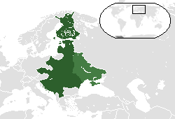
| Popis |
Беларуская (тарашкевіца): Мапа плянаванай канфэдэрацыі. Сьветлым колерам адзначаны тэрыторыі Беларусі і Ўкраіны, якія ўвайшлі ў Савецкую дзяржаву пасьля 1921.
Čeština: Mapu s vyznačením území, která by zahrnovala na Międzymorze federace. Světlejší zelená značí ukrajinské a běloruské území ovládané Sovětským svazem po roce 1921.
Deutsch: Karte zeigt die Gebiete, die die Międzymorze Föderation umfassen würde. Hellgrün bezeichnet ukrainischen und weißrussischen Gebiete von der Sowjetunion nach 1921 regiert.
English: Map showing the territories that would comprise the Międzymorze federation. Lighter green denotes Ukrainian and Belarusian territories controlled by the Soviet Union after 1921.
Español: Mapa que muestra los territorios que componen la federación Międzymorze. De color verde claro indica territorios de Ucrania y Bielorrusia controladas por la Unión Soviética después de 1921.
Hrvatski: Karta pokazuje područja koja će obuhvaćaju Międzymorze federaciju. Upaljač zelena označava ukrajinski i bjeloruski područja kontrolom Sovjetskog Saveza nakon 1921.
Italiano: Cartina con i territori che compongono la federazione Międzymorze. Accendino verde denota territori ucraini e bielorussi controllati dall'Unione Sovietica dopo il 1921.
Lietuvių: Žemėlapis rodo teritorijas, kad būtų sukaupta Międzymorze federaciją. Žiebtuvėlis žalia žymi Ukrainos ir Baltarusijos teritorijas, kontroliuojamas Sovietų Sąjungos po 1921 m.
Polski: Mapa pokazująca terytoria, które składają się na Międzymorze federacji. Lżejszy zielony oznacza Ukrainy i Białorusi terytoria kontrolowane przez ZSRR po 1921 roku.
Русский: Карта с указанием территорий, которые должны были войти в Междуморье. Светло-зеленый показывает украинские и белорусские территории, которые попали под контроль Советского Союза после 1921 года.
Slovenčina: Mapu s vyznačením územia, ktorá by zahŕňala na Międzymorze federácie. Svetlejšie zelená značí ukrajinskej a bieloruskej územie ovládané Sovietskym zväzom po roku 1921.
Українська: Карта з позначеною територією, яка мала увійти до Міжмор’я. Світло-зелений колір показує українські та білоруські території, які потрапили під контроль Радянського Союзу після 1921 року. |
| Dátum | Uploaded to pl wiki on 6 April 2007. |
| Zdroj | Uploaded to pl wiki by creator. |
| Autor | Albertus |
| Ďalšie verzie |
 |
Ja, držiteľ autorských práv k tomuto dielu ho týmto zverejňujem za podmienok nasledovných licencií:

|
Bolo udelené povolenie kopírovať, širiť a/alebo meniť tento dokument za podmienok GNU Free Documentation License, verzie 1.2 alebo ktorejkoľvek neskoršej verzie publikovanej Free Software Foundation; bez Nemenných častí, bez Textov na prednej obálke a bez Textov na zadnej obálke. Kópia tejto licencie je zahrnutá v časti nazvanej GNU Free Documentation License. |
Tento súbor je licencovaný za podmienok Creative Commons Attribution-Share Alike 3.0 Unported, 2.5 Generic, 2.0 Generic a 1.0 Generic.
- Môžete slobodne:
- zdieľať – kopírovať, šíriť a prenášať dielo
- meniť ho – upravovať dielo
- Za nasledovných podmienok:
- uvedenie autorov – Musíte spomenúť autorov (jednotlivo alebo kolektívne), poskytnúť odkaz na licenciu a uviesť, či ste niečo zmenili. Môžete to urobiť ľubovoľným primeraným spôsobom, ale nie spôsobom naznačujúcim, že poskytovateľ licencie podporuje vás alebo vaše použitie diela.
- meniť za rovnakých podmienok – Ak toto dielo zmeníte, prevediete do inej formy alebo použijete ako základ iného diela, musíte výsledok šíriť pod rovnakou alebo kompatibilnou licenciou ako originál.
Môžete si zvoliť ľubovolnú z týchto licencií.
| Poznámky | K tomuto souboru existují poznámky: Prohlédnout si poznámky na Commons |
História súboru
Po kliknutí na dátum/čas uvidíte ako súbor vyzeral vtedy.
| Dátum/Čas | Náhľad | Rozmery | Používateľ | Komentár | |
|---|---|---|---|---|---|
| aktuálna | 04:20, 12. máj 2014 | | 250 × 170 (8 KB) | Spesh531 | italian coastline fixed and island in turkey removed |
| 04:06, 12. máj 2014 |  | 250 × 170 (8 KB) | Spesh531 | fixing east prussia and lithuania borders | |
| 03:59, 12. máj 2014 |  | 250 × 170 (8 KB) | Spesh531 | further south map | |
| 03:42, 12. máj 2014 |  | 250 × 150 (7 KB) | Spesh531 | update | |
| 04:14, 17. júl 2012 |  | 250 × 150 (5 KB) | Spesh531 | Version with all proposed countries, so +Finland, updated layout | |
| 19:15, 22. apríl 2007 |  | 250 × 115 (9 KB) | Piotrus | {{Information |Description=Map showing the territories that would comprise the Międzymorze federation. Lighter green denotes Ukrainian and Belarusian territories controlled by the Soviet Union after 1921. |Source=Uploaded to pl wiki by creator. |Date=Upl |
Použitie súboru
Na tento súbor odkazuje nasledujúca stránka:
Globálne využitie súborov
Nasledovné ďalšie wiki používajú tento súbor:
- Použitie na be-tarask.wikipedia.org
- Použitie na be.wikipedia.org
- Použitie na ca.wikipedia.org
- Použitie na de.wikipedia.org
- Použitie na el.wikipedia.org
- Použitie na en.wikipedia.org
- Použitie na eo.wikipedia.org
- Použitie na es.wikipedia.org
- Použitie na et.wikipedia.org
- Použitie na hr.wikipedia.org
- Použitie na hy.wikipedia.org
- Použitie na id.wikipedia.org
- Použitie na ja.wikipedia.org
- Použitie na ka.wikipedia.org
- Použitie na lv.wikipedia.org
- Použitie na no.wikipedia.org
- Použitie na pl.wikipedia.org
- Použitie na ro.wikipedia.org
- Použitie na ru.wikipedia.org
- Použitie na sh.wikipedia.org
- Použitie na sr.wikipedia.org
- Použitie na sv.wikipedia.org
- Použitie na tr.wikipedia.org
- Použitie na uk.wikipedia.org
- Použitie na vi.wikipedia.org
- Použitie na zh.wikipedia.org