Súbor:PonticKingdom.png

Veľkosť tohto náhľadu: 718 × 600 pixelov. Iné rozlíšenia: 287 × 240 pixelov | 575 × 480 pixelov | 919 × 768 pixelov | 1 226 × 1 024 pixelov | 1 551 × 1 296 pixelov .
Pôvodný súbor (1 551 × 1 296 pixelov, veľkosť súboru: 265 KB, MIME typ: image/png)

|
Tento obrázek (skupina historical map) by měl být vytvořen pomocí vektorové grafiky jako SVG soubor. To má několik výhod; podrobnosti najdete na stránce Commons:Media for cleanup. Je-li SVG verze tohoto obrázku již k dispozici, prosím nahrajte ji. Po nahrání nahraďte tuto šablonu šablonou {{Vector version available|jméno nového obrázku.svg}}.
|
| Popis |
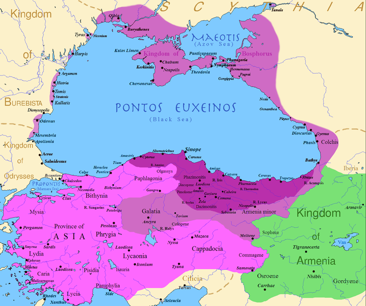
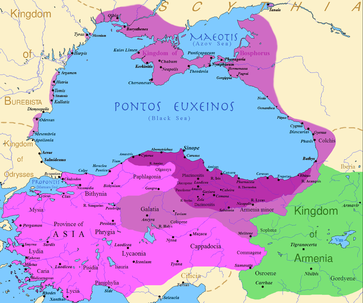
English: Map of the Kingdom of Pontus, Before the reign of Mithridates VI (darkest purple), after his conquests (purple), and his conquests in the first Mithridatic wars (pink); little adds (ancient shorelines & some greek colonies under Mithridate's rule) according with V. Yanko-Hombach, A.S. Gilbert, N. Panin, P. M. Dolukhanov: The Black Sea Flood Question: Changes in Coastline, Climate, and Human Settlement, Springer, Netherlands, 2007, and with Appianus, Plutarchus & Strabo. |
| Dátum | |
| Zdroj | I (Javierfv1212 (talk)) created this work entirely by myself. Sources, Cambridge Ancient history volume 9, Penguin atlas of Greek history and the Foreign Policy of Mithridates VI Eupator. |
| Autor | Javierfv1212 (talk) |
Licencovanie
| Toto dielo uvoľnil ako voľné dielo (public domain) jeho autor, Javierfv1212 v projekte Wikipédia (angličtina). Toto platí celosvetovo. V niektorých krajinách to zákon neumožňuje; v tom prípade: Javierfv1212 udelil komukoľvek právo používať toto dielo na ľubovoľné účely, bez akýchkoľvek podmienok ak také podmienky nevyžaduje zákon. |
Pôvodný záznam nahrávaní
Na Commons přenesl z en.wikipedia uživatel Falcorian pomocí nástroje CommonsHelper.
Původní stránka s popisem souboru byla zde. Všechna následující uživatelská jména odkazují na projekt en.wikipedia.
- 2009-07-19 23:42 Javierfv1212 1551×1296× (205182 bytes) {{Information |Description = Map of the Kingdom of Pontus, Before the reign of mithridates VI (darkest purple), after his conquests (purple), and his conquests in the first Mithridatic wars (pink). |Source = I (~~~) created this work entirel
História súboru
Po kliknutí na dátum/čas uvidíte ako súbor vyzeral vtedy.
| Dátum/Čas | Náhľad | Rozmery | Používateľ | Komentár | |
|---|---|---|---|---|---|
| aktuálna | 02:00, 9. december 2017 | | 1 551 × 1 296 (265 KB) | SteinsplitterBot | Bot: Image rotated by 90° |
| 00:00, 9. december 2017 |  | 1 296 × 1 551 (316 KB) | SteinsplitterBot | Bot: Image rotated by 270° | |
| 17:54, 22. september 2016 |  | 1 551 × 1 296 (265 KB) | Hohum | Lighten water area | |
| 11:21, 9. august 2016 |  | 1 551 × 1 296 (260 KB) | MAXHO | Details : more cities & shoreline of this time | |
| 20:57, 1. október 2015 |  | 1 551 × 1 296 (249 KB) | Spiridon Ion Cepleanu | Cosmetic again | |
| 12:55, 30. september 2015 |  | 1 551 × 1 296 (247 KB) | Spiridon Ion Cepleanu | Cosmetic colours & background names | |
| 14:21, 7. apríl 2014 |  | 1 551 × 1 296 (225 KB) | Spiridon Ion Cepleanu | Little changes (ancient shoreline & some greek colonies under Pontic rule) according with V. Yanko-Hombach, A.S. Gilbert, N. Panin, P. M. Dolukhanov: ''The Black Sea Flood Question: Changes in Coastline, Climate, and Human Settlement'', Springer, Nethe... | |
| 04:14, 20. júl 2009 |  | 1 551 × 1 296 (200 KB) | File Upload Bot (Magnus Manske) | {{BotMoveToCommons|en.wikipedia|year={{subst:CURRENTYEAR}}|month={{subst:CURRENTMONTHNAME}}|day={{subst:CURRENTDAY}}}} {{Information |Description={{en|Map of the Kingdom of Pontus, Before the reign of mithridates VI (darkest purple), after his conquests |
Použitie súboru
Na tento súbor odkazujú nasledujúce 2 stránky:
Globálne využitie súborov
Nasledovné ďalšie wiki používajú tento súbor:
- Použitie na ar.wikipedia.org
- Použitie na ast.wikipedia.org
- Použitie na azb.wikipedia.org
- Použitie na az.wikipedia.org
- Použitie na bg.wikipedia.org
- Použitie na br.wikipedia.org
- Použitie na ca.wikipedia.org
- Použitie na cs.wikipedia.org
- Použitie na da.wikipedia.org
- Použitie na de.wikipedia.org
- Použitie na el.wikipedia.org
- Použitie na en.wikipedia.org
- Použitie na es.wikipedia.org
- Použitie na et.wikipedia.org
- Použitie na eu.wikipedia.org
- Použitie na fa.wikipedia.org
- Použitie na fr.wikipedia.org
Zobraziť ďalšie globálne použitie tohto súboru.