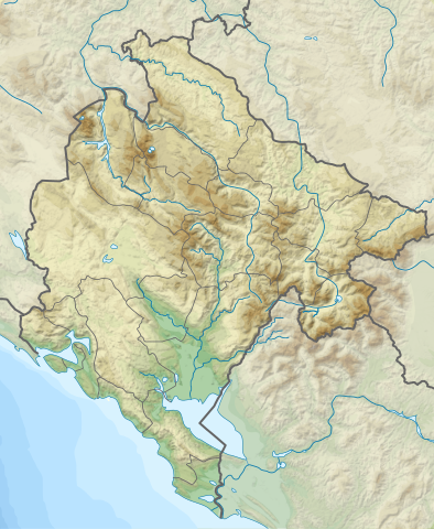
Súbor:Relief Map of Montenegro.svg

Veľkosť tohoto PNG náhľadu tohoto SVG súboru: 479 × 583 pixelov. Iné rozlíšenia: 197 × 240 pixelov | 394 × 480 pixelov | 631 × 768 pixelov | 841 × 1 024 pixelov | 1 683 × 2 048 pixelov .
Pôvodný súbor (SVG súbor, 479 × 583 pixelov, veľkosť súboru: 3,42 MB)
Zhrnutie
| Popis |
English: Relief Map of Montenegro
Српски / srpski: Топографска мапа Црне Горе |
| Dátum | |
| Zdroj | http://sr.wikipedia.org/wiki/%D0%94%D0%B0%D1%82%D0%BE%D1%82%D0%B5%D0%BA%D0%B0:Dinaric_Alps_map_sr.svg |
| Autor |
|
Licencovanie
Tento súbor podlieha licencii Creative Commons Attribution-Share Alike 3.0 Unported
- Môžete slobodne:
- zdieľať – kopírovať, šíriť a prenášať dielo
- meniť ho – upravovať dielo
- Za nasledovných podmienok:
- uvedenie autorov – Musíte spomenúť autorov (jednotlivo alebo kolektívne), poskytnúť odkaz na licenciu a uviesť, či ste niečo zmenili. Môžete to urobiť ľubovoľným primeraným spôsobom, ale nie spôsobom naznačujúcim, že poskytovateľ licencie podporuje vás alebo vaše použitie diela.
- meniť za rovnakých podmienok – Ak toto dielo zmeníte, prevediete do inej formy alebo použijete ako základ iného diela, musíte výsledok šíriť pod rovnakou alebo kompatibilnou licenciou ako originál.
História súboru
Po kliknutí na dátum/čas uvidíte ako súbor vyzeral vtedy.
| Dátum/Čas | Náhľad | Rozmery | Používateľ | Komentár | |
|---|---|---|---|---|---|
| aktuálna | 00:38, 25. júl 2020 | | 479 × 583 (3,42 MB) | Santasa99 | + the river Ćehotina. |
| 17:35, 24. júl 2020 |  | 479 × 583 (3,41 MB) | Santasa99 | Improved with addition of the missing features: rivers, lakes, and borders. | |
| 11:34, 18. marec 2012 |  | 479 × 583 (3,33 MB) | Ivan25 | borders. | |
| 13:15, 17. marec 2012 |  | 479 × 583 (3,29 MB) | Ivan25 |
Použitie súboru
Na tento súbor odkazuje nasledujúcich 10 stránok:
Globálne využitie súborov
Nasledovné ďalšie wiki používajú tento súbor:
- Použitie na ar.wikipedia.org
- Použitie na ast.wikipedia.org
- Použitie na az.wikipedia.org
- Použitie na be.wikipedia.org
- Použitie na bn.wikipedia.org
- Použitie na bs.wikipedia.org
- Použitie na ca.wikipedia.org
- Použitie na ceb.wikipedia.org
- Použitie na ce.wikipedia.org
- Použitie na da.wikipedia.org
- Použitie na de.wikipedia.org
- Použitie na de.wikivoyage.org
- Použitie na el.wikipedia.org
- Použitie na en.wikipedia.org
Zobraziť ďalšie globálne použitie tohto súboru.