Súbor:Remains of Nero's Isthmus Canal in 1881.jpg

Veľkosť tohto náhľadu: 800 × 507 pixelov. Iné rozlíšenia: 320 × 203 pixelov | 640 × 405 pixelov | 1 200 × 760 pixelov .
Pôvodný súbor (1 200 × 760 pixelov, veľkosť súboru: 225 KB, MIME typ: image/jpeg)
Zhrnutie
| Popis |
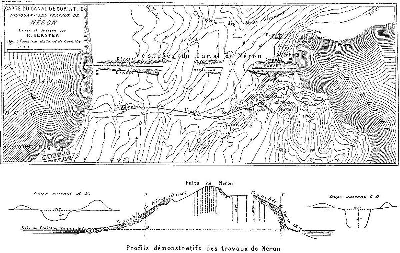
Deutsch: Überreste von Neros Projekt, einen Kanal durch den Isthmus von Korinth zu stechen (67 n. Chr.). Die dunkel schraffierten Bereiche markieren die antiken Aushubarbeiten. Die senkrechten Schächte im Bild unten dienten den Römern zur Begutachtung des Steinmaterials in der Tiefe. Die Karte wurde vom Chefingenieur des modernen Kanalprojekts Bela Gerster 1881 bei der Erkundung der Landenge angefertigt.
English: Remains of Nero's aborted project to cut through the Isthmus of Corinth (67 AD). The Roman digging is indicated by the dark shaded areas. The vertical shafts in the cross section below were excavated by the Romans to probe the stone material. The map was drawn by chief engineer Bela Gerster in 1881 during his survey for the modern canal. |
| Dátum | |
| Zdroj | Werner, Walter: "The largest ship trackway in ancient times: the Diolkos of the Isthmus of Corinth, Greece, and early attempts to build a canal", The International Journal of Nautical Archaeology, Vol. 26, No. 2 (1997), pp. 98–119 (114, Fig. 25) |
| Autor | Bela Gerster (1850–1923) |
| Ďalšie verzie |
.jpg)

|
Tento obrázek (skupina old map) by měl být vytvořen pomocí vektorové grafiky jako SVG soubor. To má několik výhod; podrobnosti najdete na stránce Commons:Media for cleanup. Je-li SVG verze tohoto obrázku již k dispozici, prosím nahrajte ji. Po nahrání nahraďte tuto šablonu šablonou {{Vector version available|jméno nového obrázku.svg}}.
|


Licencovanie
|
Autor zemřel v roce 1923, takže toto dílo je volné také v zemích, jejichž právní řád chrání majetková autorská práva po dobu života autora a 100 let po jeho smrti. Toto dílo je ve Spojených státech amerických dílem volným (public domain), protože tam bylo registrováno u U.S. Copyright Office nebo zveřejněno před 1. lednem 1929. | |
| Tento súbor bol identifikovaný, že nemá žiadne známe obmedzenia vyplývajúce z autorského zákona vrátane všetkých súvisiacich a susedných práv. | |
História súboru
Po kliknutí na dátum/čas uvidíte ako súbor vyzeral vtedy.
| Dátum/Čas | Náhľad | Rozmery | Používateľ | Komentár | |
|---|---|---|---|---|---|
| aktuálna | 16:46, 15. január 2008 | | 1 200 × 760 (225 KB) | Gun Powder Ma | == Summary == {{Information |Description= {{de| Überreste von Neros Projekt, einen Kanal durch den Isthmus von Korinth zu stechen. Die Karte wurde vom Chefingenieur des modernen Kanalprojekts Bela Gerster 1881 bei der Erkundung der Landenge gezeichnet. D |
| 16:38, 15. január 2008 |  | 751 × 476 (102 KB) | Gun Powder Ma | {{Information |Description= {{de| Überreste von Neros Projekt, einen Kanal durch den Isthmus von Korinth zu stechen. Die Karte wurde vom Chefingenieur des modernen Kanalprojekts Bela Gerster 1881 bei der Erkundung der Landenge gezeichnet. Die senkrechten |
Použitie súboru
Na tento súbor odkazuje nasledujúca stránka:
Globálne využitie súborov
Nasledovné ďalšie wiki používajú tento súbor:
- Použitie na als.wikipedia.org
- Použitie na az.wikipedia.org
- Použitie na be.wikipedia.org
- Použitie na bg.wikipedia.org
- Použitie na da.wikipedia.org
- Použitie na de.wikipedia.org
- Použitie na en.wikipedia.org
- Použitie na es.wikipedia.org
- Použitie na et.wikipedia.org
- Použitie na fi.wikipedia.org
- Použitie na fr.wikipedia.org
- Použitie na hyw.wikipedia.org
- Použitie na it.wikipedia.org
- Použitie na nn.wikipedia.org
- Použitie na no.wikipedia.org
- Použitie na ro.wikipedia.org
- Použitie na ru.wikipedia.org
- Použitie na sl.wikipedia.org
- Použitie na sq.wikipedia.org
- Použitie na sv.wikipedia.org
- Použitie na tr.wikipedia.org
- Použitie na uk.wikipedia.org
- Použitie na vi.wikipedia.org