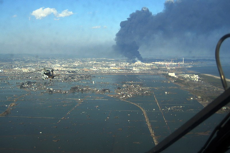
Súbor:SH-60B helicopter flies over Sendai.jpg

Veľkosť tohto náhľadu: 800 × 534 pixelov. Iné rozlíšenia: 320 × 214 pixelov | 640 × 427 pixelov | 1 024 × 684 pixelov | 1 280 × 855 pixelov | 2 763 × 1 845 pixelov .
Pôvodný súbor (2 763 × 1 845 pixelov, veľkosť súboru: 3,78 MB, MIME typ: image/jpeg)
História súboru
Po kliknutí na dátum/čas uvidíte ako súbor vyzeral vtedy.
| Dátum/Čas | Náhľad | Rozmery | Používateľ | Komentár | |
|---|---|---|---|---|---|
| aktuálna | 14:15, 16. marec 2011 |  | 2 763 × 1 845 (3,78 MB) | Citypeek | autorotate |
| 17:21, 13. marec 2011 |  | 2 877 × 1 926 (3,7 MB) | BurtAlert | {{Information |Description ={{en|1=An SH-60B helicopter assigned to the Chargers of Helicopter Antisubmarine Squadron (HS) 14 from Naval Air Facility Atsugi flies over the city of Sendai to deliver more than 1,500 pounds of food to survivors of an 8.9 |
Použitie súboru
Na tento súbor odkazuje nasledujúca stránka:
Globálne využitie súborov
Nasledovné ďalšie wiki používajú tento súbor:
- Použitie na ar.wikipedia.org
- Použitie na ar.wikinews.org
- Použitie na ast.wikipedia.org
- Použitie na as.wikipedia.org
- Použitie na azb.wikipedia.org
- Použitie na az.wikipedia.org
- Použitie na ba.wikipedia.org
- Použitie na bcl.wikipedia.org
- Použitie na bg.wikipedia.org
- Použitie na bn.wikipedia.org
- Použitie na ca.wikipedia.org
- Použitie na ckb.wikipedia.org
- Použitie na cs.wikipedia.org
- Použitie na cy.wikipedia.org
- Použitie na de.wikipedia.org
- Použitie na el.wikipedia.org
- Použitie na el.wikinews.org
- Použitie na en.wikipedia.org
- Geography of Japan
- Sendai
- Portal:Japan
- Lists of disasters
- List of earthquakes in Japan
- HSC-14
- 2011 in politics
- 2011 Tōhoku earthquake and tsunami
- User:Bencana Tsunami
- User:Bencana Tsunami/sandbox
- Devil Survivor 2: The Animation
- User:ThatGuyJabbles/sandbox
- User:Daniel Mietchen/gallery
- Portal:Tsunamis
- User:The ganymedian/sandbox
- Použitie na en.wikinews.org
- 8.9 magnitude earthquake hits Japan, causes tsunami
- Death toll rises from Japan quake
- Japan facing 'most severe crisis since World War II', says prime minister
- Japan earthquake shifts Earth's axis 10 centimetres
- Template:2011 Sendai earthquake and tsunami
- Japan earthquake death toll estimated at over 10,000
- Third explosion at Fukushima Daiichi nuclear power plant
- Fukushima reactor suffers multiple fires, radiation leak confirmed
Zobraziť ďalšie globálne použitie tohto súboru.


