Súbor:Slovenia map.png
Pôvodný súbor (2 466 × 1 890 pixelov, veľkosť súboru: 1,59 MB, MIME typ: image/png)
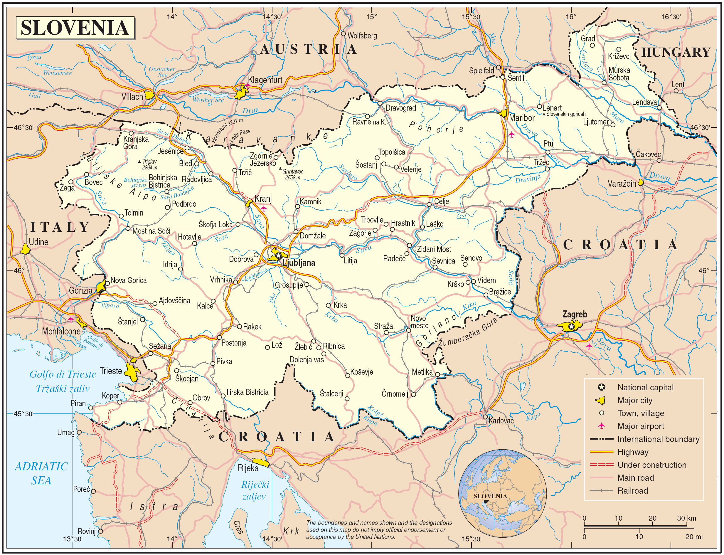
Map of Slovenia
| Popis | Map of Slovenia | |||
| Dátum | June 2004 (uploaded to wikimedia 2007-03-10) | |||
| Zdroj | The Cartographic Section of the United Nations (CSUN) | |||
| Autor | Cartographer of the United Nations | |||
| Povolenie (Využívanie tohto súboru) |
|

História súboru
Po kliknutí na dátum/čas uvidíte ako súbor vyzeral vtedy.
| Dátum/Čas | Náhľad | Rozmery | Používateľ | Komentár | |
|---|---|---|---|---|---|
| aktuálna | 23:42, 10. marec 2007 | | 2 466 × 1 890 (1,59 MB) | Gugganij | |
| 17:05, 10. marec 2007 |  | 2 466 × 1 890 (1,59 MB) | Minestrone | Map of Slovenia {{Information |Description=Map of Slovenia |Source=The Cartographic Section of the United Nations (CSUN) |Date=2007-03-10 |Author=Cartographer of the United Nations |Permission={{Template:UN map}} and the cartographer of the UN [mail |
Použitie súboru
Žiadne stránky neobsahujú odkazy na tento súbor.
Globálne využitie súborov
Nasledovné ďalšie wiki používajú tento súbor:
- Použitie na als.wikipedia.org
- Použitie na avk.wikipedia.org
- Použitie na azb.wikipedia.org
- Použitie na cs.wikipedia.org
- Použitie na da.wikipedia.org
- Použitie na de.wikipedia.org
- Použitie na el.wikipedia.org
- Použitie na en.wikipedia.org
- Použitie na fa.wikipedia.org
- Použitie na fr.wikipedia.org
- Použitie na gag.wikipedia.org
- Použitie na gd.wikipedia.org
- Použitie na gom.wikipedia.org
- Použitie na hr.wikipedia.org
- Použitie na hu.wikipedia.org
- Použitie na it.wikipedia.org
- Použitie na ko.wikipedia.org
- Použitie na lb.wikipedia.org
- Použitie na lfn.wikipedia.org
- Použitie na mzn.wikipedia.org
- Použitie na nl.wikipedia.org
- Použitie na pl.wiktionary.org
- Použitie na ps.wikipedia.org
- Použitie na sl.wikipedia.org
- Použitie na to.wikipedia.org
- Použitie na tr.wiktionary.org
- Použitie na uk.wikipedia.org
- Použitie na uk.wiktionary.org
- Použitie na www.wikidata.org