Súbor:Syrdaryamap.png
Veľkosť tohto náhľadu: 719 × 600 pixelov. Iné rozlíšenia: 288 × 240 pixelov | 576 × 480 pixelov | 820 × 684 pixelov .
Pôvodný súbor (820 × 684 pixelov, veľkosť súboru: 936 KB, MIME typ: image/png)
Zhrnutie

|
Tento obrázek (skupina map) by měl být vytvořen pomocí vektorové grafiky jako SVG soubor. To má několik výhod; podrobnosti najdete na stránce Commons:Media for cleanup. Je-li SVG verze tohoto obrázku již k dispozici, prosím nahrajte ji. Po nahrání nahraďte tuto šablonu šablonou {{Vector version available|jméno nového obrázku.svg}}.
|
| Popis |
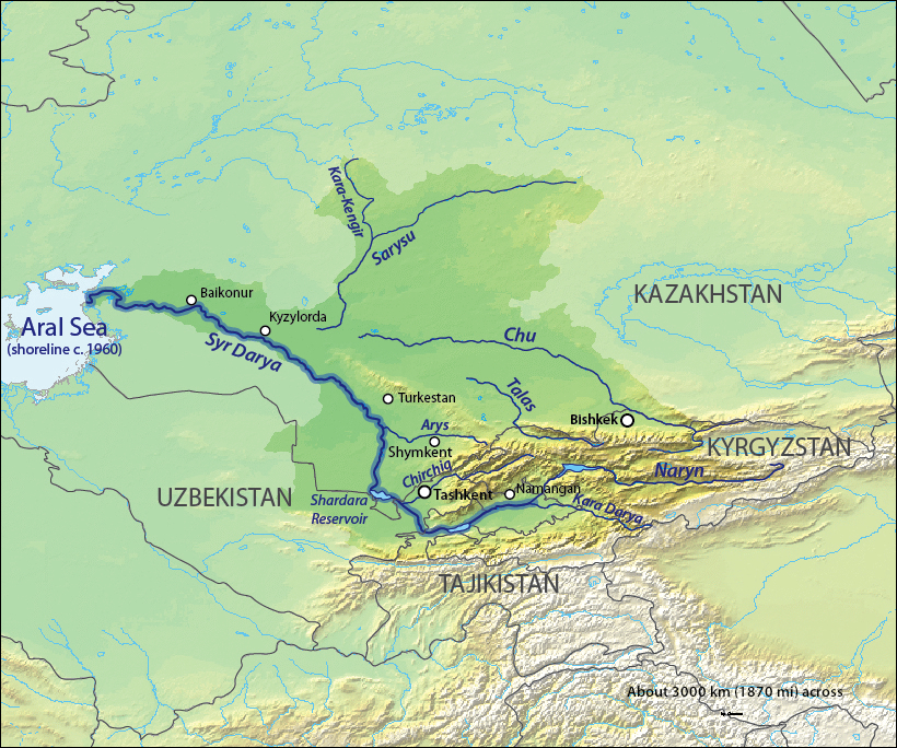
English: Map of the Syr Darya Basin watershed, of the Syr Darya and Chu Rivers — in Central Asia.
Қазақша: Сырдария
Татарча / tatarça: Сырдәрья |
| Dátum | to 06 |
| Zdroj | Background and river course data from http://www2.demis.nl/mapserver/mapper.asp |
| Autor | Background layer attributed to DEMIS Mapserver, map created by Shannon1 |
| Povolenie (Využívanie tohto súboru) |
Map created from DEMIS Mapserver, which are public domain. |
| Ďalšie verzie |
Derivative works of this file: |
Licencovanie
Ja, držiteľ autorských práv k tomuto dielu ho týmto zverejňujem za podmienok nasledovných licencií:

|
Bolo udelené povolenie kopírovať, širiť a/alebo meniť tento dokument za podmienok GNU Free Documentation License, verzie 1.2 alebo ktorejkoľvek neskoršej verzie publikovanej Free Software Foundation; bez Nemenných častí, bez Textov na prednej obálke a bez Textov na zadnej obálke. Kópia tejto licencie je zahrnutá v časti nazvanej GNU Free Documentation License. |
This file is licensed under the Creative Commons Attribution-Share Alike 4.0 International, 3.0 Unported, 2.5 Generic, 2.0 Generic and 1.0 Generic license.
- Môžete slobodne:
- zdieľať – kopírovať, šíriť a prenášať dielo
- meniť ho – upravovať dielo
- Za nasledovných podmienok:
- uvedenie autorov – Musíte spomenúť autorov (jednotlivo alebo kolektívne), poskytnúť odkaz na licenciu a uviesť, či ste niečo zmenili. Môžete to urobiť ľubovoľným primeraným spôsobom, ale nie spôsobom naznačujúcim, že poskytovateľ licencie podporuje vás alebo vaše použitie diela.
- meniť za rovnakých podmienok – Ak toto dielo zmeníte, prevediete do inej formy alebo použijete ako základ iného diela, musíte výsledok šíriť pod rovnakou alebo kompatibilnou licenciou ako originál.
Môžete si zvoliť ľubovolnú z týchto licencií.
História súboru
Po kliknutí na dátum/čas uvidíte ako súbor vyzeral vtedy.
| Dátum/Čas | Náhľad | Rozmery | Používateľ | Komentár | |
|---|---|---|---|---|---|
| aktuálna | 03:11, 18. október 2013 | | 820 × 684 (936 KB) | Shannon1 | redrew and fixed watershed boundary |
| 09:21, 8. január 2011 |  | 1 101 × 866 (1,65 MB) | Sibom | chu | |
| 09:20, 8. január 2011 |  | 1 101 × 866 (1,65 MB) | Sibom | чу | |
| 03:04, 7. február 2010 |  | 1 101 × 866 (1,51 MB) | Shannon1 | {{Information |Description={{en|1=Map of the watershed of the Syr Darya in Central Asia, that drains to the Aral Sea.}} |Source=Background and river course data from http://www2.demis.nl/mapserver/mapper.asp |Author=Background layer attributed to DEMIS M |
Použitie súboru
Na tento súbor odkazuje nasledujúca stránka:
Globálne využitie súborov
Nasledovné ďalšie wiki používajú tento súbor:
- Použitie na af.wikipedia.org
- Použitie na ar.wikipedia.org
- Použitie na ast.wikipedia.org
- Použitie na bg.wikipedia.org
- Použitie na bh.wikipedia.org
- Použitie na bn.wikipedia.org
- Použitie na cs.wikipedia.org
- Použitie na cv.wikipedia.org
- Použitie na da.wikipedia.org
- Použitie na de.wikipedia.org
- Použitie na en.wikipedia.org
- Použitie na es.wikipedia.org
- Použitie na et.wikipedia.org
- Použitie na fi.wikipedia.org
- Použitie na fr.wikipedia.org
- Použitie na he.wikipedia.org
- Použitie na hi.wikipedia.org
- Použitie na hr.wikipedia.org
- Použitie na hu.wikipedia.org
- Použitie na hy.wikipedia.org
- Použitie na id.wikipedia.org
Zobraziť ďalšie globálne použitie tohto súboru.