Súbor:2022 Russian invasion of Ukraine.svg

Pôvodný súbor (SVG súbor, 2 199 × 1 478 pixelov, veľkosť súboru: 3,7 MB)
Rules for editing the map
|
| All edit warring, adding of unsourced information or performing a color change without consensus may result in the user being blocked. All contributions should first be discussed on the talk page. |
Zhrnutie

|
This file may be updated to reflect new information. If you wish to use a specific version of the file without new updates being mirrored, please upload the required version as a separate file. |
| Popis | |||
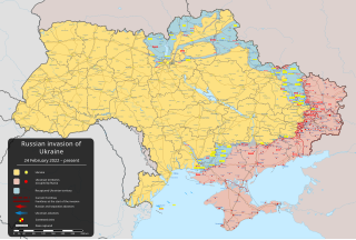
| Dátum | 24. februára 2022 (first version) | ||
| Zdroj |
Vlastní tvorba založená na: Russo-Ukrainian conflict (2014-2022).svg od Rr016 & Ukraine adm location map improved.svg od Yakiv Gluck
|
||
| Autor | Viewsridge | ||
| Ďalšie verzie |
[]
|
||
| SVG vývoj | Táto grafika bola vytvorená pomocou Inkscape. This map is translated using SVG switch elements: all translations are stored in the same file.
|


.gif)

.gif)


_en.png)
_vi.png)
_ru.png)
.svg)
This file is translated using SVG <switch> elements. All translations are stored in the same file! Learn more.
For most Wikipedia projects, you can embed the file normally (without a To translate the text into your language, you can use the SVG Translate tool. Alternatively, you can download the file to your computer, add your translations using whatever software you're familiar with, and re-upload it with the same name. You will find help in Graphics Lab if you're not sure how to do this. |
Licencovanie
- Môžete slobodne:
- zdieľať – kopírovať, šíriť a prenášať dielo
- meniť ho – upravovať dielo
- Za nasledovných podmienok:
- uvedenie autorov – Musíte spomenúť autorov (jednotlivo alebo kolektívne), poskytnúť odkaz na licenciu a uviesť, či ste niečo zmenili. Môžete to urobiť ľubovoľným primeraným spôsobom, ale nie spôsobom naznačujúcim, že poskytovateľ licencie podporuje vás alebo vaše použitie diela.
- meniť za rovnakých podmienok – Ak toto dielo zmeníte, prevediete do inej formy alebo použijete ako základ iného diela, musíte výsledok šíriť pod rovnakou alebo kompatibilnou licenciou ako originál.
História súboru
Po kliknutí na dátum/čas uvidíte ako súbor vyzeral vtedy.
| Dátum/Čas | Náhľad | Rozmery | Používateľ | Komentár | |
|---|---|---|---|---|---|
| aktuálna | 16:32, 6. máj 2024 | | 2 199 × 1 478 (3,7 MB) | Alexiscoutinho | Updated Vuhledar per detailed map |
| 05:50, 6. máj 2024 |  | 2 199 × 1 478 (3,7 MB) | Physeters | Updates north of Avdiivka per the ISW | |
| 00:17, 1. máj 2024 |  | 2 199 × 1 478 (3,7 MB) | Physeters | Updates across the front per the ISW | |
| 23:30, 30. apríl 2024 |  | 2 199 × 1 478 (3,7 MB) | Alexiscoutinho | Updated Kyslivka & Pervomaiske per Territorial control page | |
| 06:02, 24. apríl 2024 |  | 2 199 × 1 478 (3,7 MB) | Physeters | Small updates per the ISW; update Novmykhailivka & Heorhiivka per the ISW | |
| 09:11, 21. apríl 2024 |  | 2 199 × 1 478 (3,7 MB) | Physeters | Updates per the ISW; mark Krasnohorivka & Bilohorivka as contested per the ISW | |
| 07:00, 17. apríl 2024 |  | 2 199 × 1 478 (3,7 MB) | Physeters | Small updates per the ISW | |
| 07:38, 8. apríl 2024 |  | 2 199 × 1 478 (3,7 MB) | Physeters | Small updates per the ISW; add Synkivka, Kyslivka, Novoiehorivka, Terny, Heorhiivka, and Novomykhailivka | |
| 05:33, 3. apríl 2024 |  | 2 199 × 1 478 (3,7 MB) | Physeters | Updates east of Avdiivka per the ISW | |
| 03:04, 27. marec 2024 |  | 2 199 × 1 478 (3,7 MB) | Physeters | Small updates per the ISW |
Použitie súboru
Na tento súbor odkazuje nasledujúca stránka:
Globálne využitie súborov
Nasledovné ďalšie wiki používajú tento súbor:
- Použitie na af.wikipedia.org
- Použitie na als.wikipedia.org
- Použitie na am.wikipedia.org
- Použitie na ang.wikipedia.org
- Použitie na an.wikipedia.org
- Použitie na ar.wikipedia.org
- Použitie na ary.wikipedia.org
- Použitie na arz.wikipedia.org
- Použitie na ast.wikipedia.org
- Použitie na azb.wikipedia.org
- Použitie na az.wikipedia.org
- Použitie na bat-smg.wikipedia.org
- Použitie na bcl.wikipedia.org
- Použitie na be-tarask.wikipedia.org
- Použitie na be.wikipedia.org
- Použitie na bg.wikipedia.org
- Použitie na bh.wikipedia.org
- Použitie na bn.wikipedia.org
- Použitie na br.wikipedia.org
- Použitie na bs.wikipedia.org
- Použitie na bxr.wikipedia.org
- Použitie na ca.wikipedia.org
Zobraziť ďalšie globálne použitie tohto súboru.