Súbor:Auroras over North America.jpg

Veľkosť tohto náhľadu: 600 × 600 pixelov. Iné rozlíšenia: 240 × 240 pixelov | 480 × 480 pixelov | 768 × 768 pixelov | 1 024 × 1 024 pixelov | 2 048 × 2 048 pixelov | 3 677 × 3 677 pixelov .
Pôvodný súbor (3 677 × 3 677 pixelov, veľkosť súboru: 2,05 MB, MIME typ: image/jpeg)
Zhrnutie
| Popis |
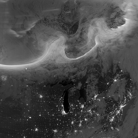
Deutsch: Bild der Aurora borealis vom frühen Morgen des 8. Oktobers 2012, aufgenommen mit dem "Tag-Nacht-Band" (DNB, 505 bis 890 Nanometer – hauptsächlich sichtbares Licht von grün bis nahem ultraviolett) der Visible Infrared Imaging Radiometer Suite (VIIRS) an Bord des Satelliten Suomi National Polar-orbiting Partnership (Suomi NPP). Die Lichter im Bild ziehen sich über die kanadischen Provinzen Quebec und Ontario und sind Teil des Gesamtovals, das sich durch einen geomagnetischen Sturm bis in mittlere Breiten hinab ausdehnte. English: Using the “day-night band” (DNB, 505 to 890 nanometres – primarily visible light from green to near visible infrared) of the Visible Infrared Imaging Radiometer Suite (VIIRS), the Suomi National Polar-orbiting Partnership (Suomi NPP) satellite acquired this view of the aurora borealis early on the morning of October 8, 2012. The northern lights stretch across Canada’s Quebec and Ontario provinces in the image, and are part of the auroral oval that expanded to middle latitudes because of a geomagnetic storm. |
| Dátum | |
| Zdroj | NASA Earth Observatory |
| Autor | Jesse Allen and Robert Simmon |
| Pozícia kamery | | Tento a ďalšie obrázky na: OpenStreetMap |
|---|
| Annotations | This image is annotated: View the annotations at Commons |
Licencovanie
| This file is in the public domain in the United States because it was solely created by NASA. NASA copyright policy states that "NASA material is not protected by copyright unless noted". (See Template:PD-USGov, NASA copyright policy page or JPL Image Use Policy.) | ||
 |
Warnings:
|
História súboru
Po kliknutí na dátum/čas uvidíte ako súbor vyzeral vtedy.
| Dátum/Čas | Náhľad | Rozmery | Používateľ | Komentár | |
|---|---|---|---|---|---|
| aktuálna | 10:00, 12. október 2012 | | 3 677 × 3 677 (2,05 MB) | Originalwana | {{Information |Description ={{en|1=Using the “day-night band” (DNB) of the Visible Infrared Imaging Radiometer Suite (VIIRS), the Suomi National Polar-orbiting Partnership (Suomi NPP) satellite acquired this view of the aurora borealis early on ... |
Použitie súboru
Na tento súbor odkazujú nasledujúce 2 stránky:
Globálne využitie súborov
Nasledovné ďalšie wiki používajú tento súbor:
- Použitie na et.wikipedia.org
- Použitie na fr.wikipedia.org
- Použitie na id.wikipedia.org
- Použitie na zh.wikipedia.org