Súbor:Basse Mesopotamie DA.PNG
Nie je dostupné vyššie rozlíšenie.
Basse_Mesopotamie_DA.PNG (440 × 393 pixelov, veľkosť súboru: 158 KB, MIME typ: image/png)
| Popis |
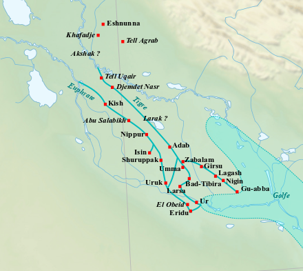
English: Map of the main cities of Lower Mesopotamia during the Early Dynastic period, with the approximate course of the rivers and the ancient shoreline of the Gulf. Français : Carte des principales villes de la Basse Mésopotamie durant la période des Dynasties Archaïques, avec le tracé approximatif des fleuves et l'ancien trait de côte du Golfe. |
| Dátum | (UTC) |
| Zdroj | |
| Autor |
|
| Toto je upravený obrázek, což znamená, že byl oproti původní verzi digitálně změněn. Úpravy: Ajout du tracé approximatif des fleuves et du trait de côté du Golfe, et de villes.. Původní verzi je možné zhlédnout zde: Near East topographic map-blank.svg. Úpravy provedl Zunkir.
|
Ja, držiteľ autorských práv k tomuto dielu ho týmto zverejňujem za podmienok nasledovných licencií:
Tento súbor je licencovaný za podmienok Creative Commons Attribution-Share Alike 3.0 Unported, 2.5 Generic, 2.0 Generic a 1.0 Generic.
- Môžete slobodne:
- zdieľať – kopírovať, šíriť a prenášať dielo
- meniť ho – upravovať dielo
- Za nasledovných podmienok:
- uvedenie autorov – Musíte spomenúť autorov (jednotlivo alebo kolektívne), poskytnúť odkaz na licenciu a uviesť, či ste niečo zmenili. Môžete to urobiť ľubovoľným primeraným spôsobom, ale nie spôsobom naznačujúcim, že poskytovateľ licencie podporuje vás alebo vaše použitie diela.
- meniť za rovnakých podmienok – Ak toto dielo zmeníte, prevediete do inej formy alebo použijete ako základ iného diela, musíte výsledok šíriť pod rovnakou alebo kompatibilnou licenciou ako originál.

|
Bolo udelené povolenie kopírovať, širiť a/alebo meniť tento dokument za podmienok GNU Free Documentation License, verzie 1.2 alebo ktorejkoľvek neskoršej verzie publikovanej Free Software Foundation; bez Nemenných častí, bez Textov na prednej obálke a bez Textov na zadnej obálke. Kópia tejto licencie je zahrnutá v časti nazvanej GNU Free Documentation License. |
Môžete si zvoliť ľubovolnú z týchto licencií.
Pôvodný záznam nahrávaní
This image is a derivative work of the following images:
- File:Near_East_topographic_map-blank.svg licensed with Cc-by-sa-3.0,2.5,2.0,1.0, GFDL
- 2009-08-18T18:31:37Z Sémhur 2425x1581 (2442670 Bytes) 3 - New try
- 2009-08-17T15:39:22Z Sémhur 2425x1581 (1815374 Bytes) 2 - With the background...
- 2009-08-17T15:37:36Z Sémhur 2425x1581 (2836 Bytes) {{Information |Description={{en|1=Blank physical map of the [[:en:Near East|Near East]]}} {{fr|1=Carte physique vierge du [[:fr:Proche-Orient|Proche-Orient]].}} |Source={{own}} |Author=[[User:Sémhur|Sémhur]] |Date=2008-08-1
Uploaded with derivativeFX
História súboru
Po kliknutí na dátum/čas uvidíte ako súbor vyzeral vtedy.
| Dátum/Čas | Náhľad | Rozmery | Používateľ | Komentár | |
|---|---|---|---|---|---|
| aktuálna | 22:44, 17. február 2023 | | 440 × 393 (158 KB) | Zunkir | cote et cours d'eau |
| 18:20, 4. február 2018 |  | 440 × 393 (181 KB) | Zunkir | Tracé des cours d'eau, locations sites. | |
| 12:04, 28. september 2010 |  | 1 021 × 730 (817 KB) | Zunkir | {{Information |Description={{en|1=Map of the main cities of Lower Mesopotamia during the Early Dynastic period, with the approximate course of the rivers and the ancient shoreline of the Gulf.}} {{fr|1=Carte des principales villes de la Basse Mésopotamie |
Použitie súboru
Na tento súbor odkazuje nasledujúca stránka:
Globálne využitie súborov
Nasledovné ďalšie wiki používajú tento súbor:
- Použitie na af.wikipedia.org
- Použitie na ar.wikipedia.org
- Použitie na arz.wikipedia.org
- Použitie na ast.wikipedia.org
- Použitie na az.wikipedia.org
- Použitie na ba.wikipedia.org
- Použitie na be.wikipedia.org
- Použitie na ca.wikipedia.org
- Použitie na cs.wikipedia.org
- Použitie na cy.wikipedia.org
- Použitie na de.wikipedia.org
- Použitie na diq.wikipedia.org
- Použitie na en.wikipedia.org
- Použitie na eo.wikipedia.org
- Použitie na es.wikipedia.org
- Použitie na eu.wikipedia.org
- Použitie na fa.wikipedia.org
- Použitie na fi.wikipedia.org
- Použitie na fr.wikipedia.org
Zobraziť ďalšie globálne použitie tohto súboru.