Súbor:Biafra independent state map-de.svg

Veľkosť tohoto PNG náhľadu tohoto SVG súboru: 776 × 600 pixelov. Iné rozlíšenia: 311 × 240 pixelov | 621 × 480 pixelov | 994 × 768 pixelov | 1 280 × 989 pixelov | 2 560 × 1 978 pixelov | 1 100 × 850 pixelov .
Pôvodný súbor (SVG súbor, 1 100 × 850 pixelov, veľkosť súboru: 455 KB)

|
Tento soubor ve formátu SVG obsahuje vložený text či texty, které lze přeložit do češtiny. K překladu je možné použít některé vektorové editory, textový editor nebo nástroj SVG Překladač. Pro více informací navštivte Nápovědu k překladům souborů SVG. |
Zhrnutie
| Popis |
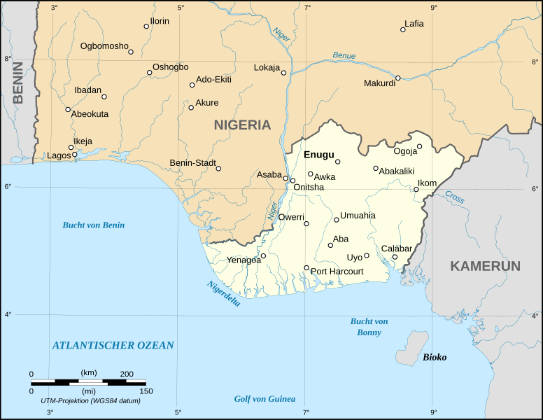
English: Map of the secessionist state of the Republic of Biafra (1967 – 1970) as in May 1967.
Note: The western boundary may not be accurate due to the low precision of the reference maps used which are also contradictory. UTM projection ; WGS 84 datum |
| Dátum | September 2008 (new version) |
| Zdroj |
Own work
|
| Autor | Eric Gaba (Sting - fr:Sting), Translation: Bohr |
| Povolenie (Využívanie tohto súboru) |
GFDL + CC-BY-SA |
| Ďalšie verzie |
[]
|


Licencovanie

|
Bolo udelené povolenie kopírovať, širiť a/alebo meniť tento dokument za podmienok GNU Free Documentation License, verzie 1.2 alebo ktorejkoľvek neskoršej verzie publikovanej Free Software Foundation; bez Nemenných častí, bez Textov na prednej obálke a bez Textov na zadnej obálke. Kópia tejto licencie je zahrnutá v časti nazvanej GNU Free Documentation License. |
| Tento súbor podlieha licencii Creative Commons Attribution-Share Alike 3.0 Unported | ||
| ||
| Táto šablóna licencie bola pridaná k tomuto súboru počas aktualizácie licencovania GFDL. |
História súboru
Po kliknutí na dátum/čas uvidíte ako súbor vyzeral vtedy.
| Dátum/Čas | Náhľad | Rozmery | Používateľ | Komentár | |
|---|---|---|---|---|---|
| aktuálna | 13:22, 3. september 2008 | | 1 100 × 850 (455 KB) | Sting | Oup : forgot to delete a hidden layer |
| 13:19, 3. september 2008 |  | 1 100 × 850 (494 KB) | Sting | New map using NGDC GSHHS and WDBII data ; new standard colors ; boundaries correction | |
| 19:55, 18. december 2006 |  | 1 100 × 850 (162 KB) | Bohr~commonswiki | == Summary == {{Information| |Description=Map of the secessionist state of the Republic of Biafra (1967 – 1970) in German |Source=Own work<br/>Background reference map : Microsoft Encarta atlas (1999 edition)<br/>Biafra independent state borders referen |
Použitie súboru
Na tento súbor odkazuje nasledujúca stránka:
Globálne využitie súborov
Nasledovné ďalšie wiki používajú tento súbor:
- Použitie na als.wikipedia.org
- Použitie na cs.wikipedia.org
- Použitie na de.wikipedia.org
- Použitie na eo.wikipedia.org
- Použitie na frr.wikipedia.org