Súbor:Earth oblateness to scale.svg

Veľkosť tohoto PNG náhľadu tohoto SVG súboru: 512 × 512 pixelov. Iné rozlíšenia: 240 × 240 pixelov | 480 × 480 pixelov | 768 × 768 pixelov | 1 024 × 1 024 pixelov | 2 048 × 2 048 pixelov .
Pôvodný súbor (SVG súbor, 512 × 512 pixelov, veľkosť súboru: 2 KB)
Zhrnutie
| Popis |
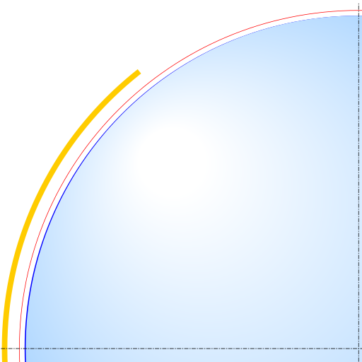
English: Scale drawing of the oblateness of the 2003 IERS reference ellipsoid. The outer edge of the dark blue line is an ellipse with the same eccentricity as that of the Earth, with North at the top. For comparison, the outer edge of the light blue area is a circle of diameter equal to the minor axis (a point on the equator, to its antipode). The red line denotes the Karman line (100 km altitude) and the yellow area, the range of the International Space Station (330-435 km altitude, 51.65-degree orbital inclination). |
| Dátum | |
| Zdroj | Vlastné dielo |
| Autor | Cmglee |
Licencovanie
Ja, držiteľ autorských práv k tomuto dielu ho týmto zverejňujem za podmienok nasledovných licencií:
Tento súbor podlieha licencii Creative Commons Attribution-Share Alike 3.0 Unported
- Môžete slobodne:
- zdieľať – kopírovať, šíriť a prenášať dielo
- meniť ho – upravovať dielo
- Za nasledovných podmienok:
- uvedenie autorov – Musíte spomenúť autorov (jednotlivo alebo kolektívne), poskytnúť odkaz na licenciu a uviesť, či ste niečo zmenili. Môžete to urobiť ľubovoľným primeraným spôsobom, ale nie spôsobom naznačujúcim, že poskytovateľ licencie podporuje vás alebo vaše použitie diela.
- meniť za rovnakých podmienok – Ak toto dielo zmeníte, prevediete do inej formy alebo použijete ako základ iného diela, musíte výsledok šíriť pod rovnakou alebo kompatibilnou licenciou ako originál.

|
Bolo udelené povolenie kopírovať, širiť a/alebo meniť tento dokument za podmienok GNU Free Documentation License, verzie 1.2 alebo ktorejkoľvek neskoršej verzie publikovanej Free Software Foundation; bez Nemenných častí, bez Textov na prednej obálke a bez Textov na zadnej obálke. Kópia tejto licencie je zahrnutá v časti nazvanej GNU Free Documentation License. |
Môžete si zvoliť ľubovolnú z týchto licencií.
História súboru
Po kliknutí na dátum/čas uvidíte ako súbor vyzeral vtedy.
| Dátum/Čas | Náhľad | Rozmery | Používateľ | Komentár | |
|---|---|---|---|---|---|
| aktuálna | 23:52, 29. marec 2015 | | 512 × 512 (2 KB) | Cmglee | Show more of ISS domain. |
| 23:42, 29. marec 2015 |  | 512 × 512 (2 KB) | Cmglee | {{Information |Description ={{en|1=Scale drawing of the oblateness of a reference geoid. The outer edge of the dark blue line is an ellipse with the same eccentricity as that of the Earth, with north at the top, For comparison, the outer edge of lig... |
Použitie súboru
Na tento súbor odkazuje nasledujúca stránka:
Globálne využitie súborov
Nasledovné ďalšie wiki používajú tento súbor:
- Použitie na ar.wikipedia.org
- Použitie na az.wikipedia.org
- Použitie na bg.wikipedia.org
- Použitie na bn.wikipedia.org
- Použitie na da.wikipedia.org
- Použitie na en.wikipedia.org
- Použitie na es.wikipedia.org
- Použitie na pt.wikipedia.org
- Použitie na sv.wikipedia.org
- Použitie na tr.wikipedia.org