Súbor:France-Constituent-Lands.png

Veľkosť tohto náhľadu: 606 × 599 pixelov. Iné rozlíšenia: 243 × 240 pixelov | 485 × 480 pixelov | 777 × 768 pixelov | 1 035 × 1 024 pixelov | 2 071 × 2 048 pixelov | 3 337 × 3 300 pixelov .
Pôvodný súbor (3 337 × 3 300 pixelov, veľkosť súboru: 382 KB, MIME typ: image/png)

|
Tento obrázek (skupina map) by měl být vytvořen pomocí vektorové grafiky jako SVG soubor. To má několik výhod; podrobnosti najdete na stránce Commons:Media for cleanup. Je-li SVG verze tohoto obrázku již k dispozici, prosím nahrajte ji. Po nahrání nahraďte tuto šablonu šablonou {{Vector version available|jméno nového obrázku.svg}}.
|
Zhrnutie
| Popis |
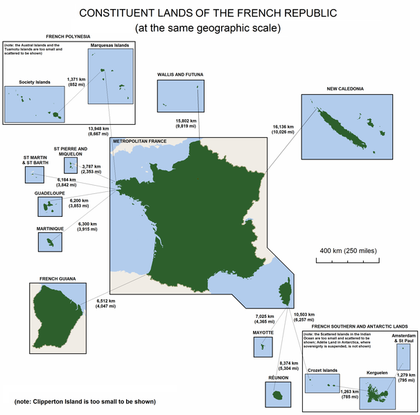
English: The constituent lands of the French Republic |
| Dátum | |
| Zdroj | Vlastné dielo |
| Autor | Godefroy |
| Ďalšie verzie |
|

Licencovanie
Ja, držiteľ autorských práv k tomuto dielu ho týmto zverejňujem za podmienok nasledovných licencií:

|
Bolo udelené povolenie kopírovať, širiť a/alebo meniť tento dokument za podmienok GNU Free Documentation License, verzie 1.2 alebo ktorejkoľvek neskoršej verzie publikovanej Free Software Foundation; bez Nemenných častí, bez Textov na prednej obálke a bez Textov na zadnej obálke. Kópia tejto licencie je zahrnutá v časti nazvanej GNU Free Documentation License. |
| Tento súbor podlieha licencii Creative Commons Attribution-Share Alike 3.0 Unported | ||
| ||
| Táto šablóna licencie bola pridaná k tomuto súboru počas aktualizácie licencovania GFDL. |
Môžete si zvoliť ľubovolnú z týchto licencií.
História súboru
Po kliknutí na dátum/čas uvidíte ako súbor vyzeral vtedy.
| Dátum/Čas | Náhľad | Rozmery | Používateľ | Komentár | |
|---|---|---|---|---|---|
| aktuálna | 15:47, 7. november 2010 | | 3 337 × 3 300 (382 KB) | Rosss | Moved French language map to a separate file |
| 02:58, 6. september 2010 |  | 3 337 × 3 300 (299 KB) | Hypersite | Correction a few mistakes and showing of forgotten territories. -- Correction de petites erreurs et ajouts de territoires oublié. | |
| 15:52, 17. apríl 2008 |  | 3 337 × 3 300 (382 KB) | Godefroy~commonswiki | {{Information |Description= The constituent lands of the French Republic |Source=self-made |Date= April 17, 2008 |Author= Godefroy |Permission= |other_versions= }} |
Použitie súboru
Na tento súbor odkazuje nasledujúca stránka:
Globálne využitie súborov
Nasledovné ďalšie wiki používajú tento súbor:
- Použitie na an.wikipedia.org
- Použitie na ast.wikipedia.org
- Použitie na br.wikipedia.org
- Použitie na cs.wikipedia.org
- Použitie na de.wikipedia.org
- Použitie na en.wikipedia.org
- Použitie na en.wikibooks.org
- Použitie na es.wikipedia.org
- Použitie na et.wikipedia.org
- Použitie na eu.wikipedia.org
- Použitie na fa.wikipedia.org
- Použitie na fr.wikipedia.org
- Použitie na gl.wikipedia.org
- Použitie na he.wikipedia.org
- Použitie na hi.wikipedia.org
- Použitie na hy.wikipedia.org
- Použitie na id.wikipedia.org
- Použitie na ja.wikipedia.org
- Použitie na ka.wikipedia.org
- Použitie na km.wikipedia.org
- Použitie na lfn.wikipedia.org
- Použitie na lld.wikipedia.org
- Použitie na lv.wikipedia.org
- Použitie na ms.wikipedia.org
- Použitie na nn.wikipedia.org
- Použitie na no.wikipedia.org
- Použitie na pdc.wikipedia.org
Zobraziť ďalšie globálne použitie tohto súboru.