Súbor:Grande Comore topographic map-fr.svg

Veľkosť tohoto PNG náhľadu tohoto SVG súboru: 421 × 599 pixelov. Iné rozlíšenia: 168 × 240 pixelov | 337 × 480 pixelov | 539 × 768 pixelov | 719 × 1 024 pixelov | 1 439 × 2 048 pixelov | 1 200 × 1 708 pixelov .
Pôvodný súbor (SVG súbor, 1 200 × 1 708 pixelov, veľkosť súboru: 1,31 MB)
Zhrnutie
| Popis |
UTM projection, WGS84 datum
|
| Dátum | |
| Zdroj |
Vlastné dielo
|
| Autor | Ikonact |
| Ďalšie verzie |
|

Licencovanie
Ja, držiteľ autorských práv k tomuto dielu ho týmto zverejňujem za podmienok nasledovných licencií:
Tento súbor podlieha licencii Creative Commons Attribution-Share Alike 3.0 Unported
- Môžete slobodne:
- zdieľať – kopírovať, šíriť a prenášať dielo
- meniť ho – upravovať dielo
- Za nasledovných podmienok:
- uvedenie autorov – Musíte spomenúť autorov (jednotlivo alebo kolektívne), poskytnúť odkaz na licenciu a uviesť, či ste niečo zmenili. Môžete to urobiť ľubovoľným primeraným spôsobom, ale nie spôsobom naznačujúcim, že poskytovateľ licencie podporuje vás alebo vaše použitie diela.
- meniť za rovnakých podmienok – Ak toto dielo zmeníte, prevediete do inej formy alebo použijete ako základ iného diela, musíte výsledok šíriť pod rovnakou alebo kompatibilnou licenciou ako originál.

|
Bolo udelené povolenie kopírovať, širiť a/alebo meniť tento dokument za podmienok GNU Free Documentation License, verzie 1.2 alebo ktorejkoľvek neskoršej verzie publikovanej Free Software Foundation; bez Nemenných častí, bez Textov na prednej obálke a bez Textov na zadnej obálke. Kópia tejto licencie je zahrnutá v časti nazvanej GNU Free Documentation License. |
Môžete si zvoliť ľubovolnú z týchto licencií.
História súboru
Po kliknutí na dátum/čas uvidíte ako súbor vyzeral vtedy.
| Dátum/Čas | Náhľad | Rozmery | Používateľ | Komentár | |
|---|---|---|---|---|---|
| aktuálna | 12:52, 26. október 2011 | | 1 200 × 1 708 (1,31 MB) | Ikonact | corrected issue with borders |
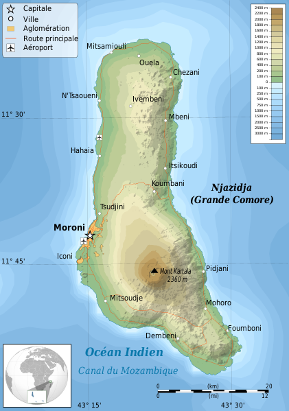
| 07:15, 15. október 2011 |  | 1 200 × 1 708 (1,4 MB) | Ikonact | {{Information |Description ={{en|1=Topographic map of Grande Comore,Comoros }} {{fr|1=Carte topographiaue Grande Comore,Archipel des Comores}} UTM projection, |
Použitie súboru
Na tento súbor odkazuje nasledujúca stránka:
Globálne využitie súborov
Nasledovné ďalšie wiki používajú tento súbor:
- Použitie na ar.wikipedia.org
- Použitie na arz.wikipedia.org
- Použitie na ast.wikipedia.org
- Použitie na az.wikipedia.org
- Použitie na be.wikipedia.org
- Použitie na ca.wikipedia.org
- Použitie na es.wikipedia.org
- Použitie na eu.wikipedia.org
- Použitie na fr.wikipedia.org
- Použitie na gl.wikipedia.org
- Použitie na ha.wikipedia.org
- Použitie na it.wikipedia.org
- Použitie na it.wikivoyage.org
- Použitie na ja.wikipedia.org
- Použitie na mg.wikipedia.org
- Použitie na mk.wikipedia.org
- Použitie na nl.wikipedia.org
- Použitie na pl.wikipedia.org
- Použitie na ru.wikipedia.org
- Použitie na uk.wikipedia.org
- Použitie na www.wikidata.org