Súbor:Map-of-southeast-asia 900 CE.png
Veľkosť tohto náhľadu: 426 × 600 pixelov. Iné rozlíšenia: 170 × 240 pixelov | 341 × 480 pixelov | 791 × 1 114 pixelov .
Pôvodný súbor (791 × 1 114 pixelov, veľkosť súboru: 182 KB, MIME typ: image/png)
khmerempire3.jpg
Zhrnutie
| Popis |
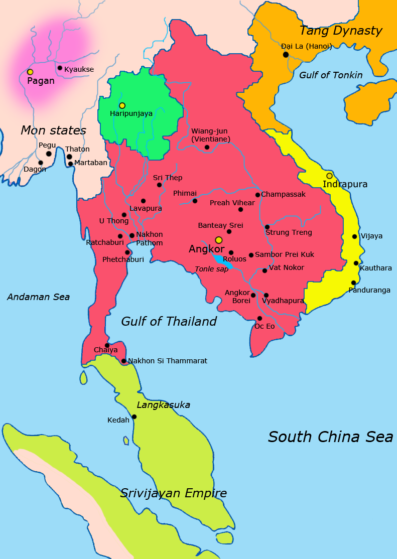
English: Map of Southeast Asia circa 900 CE, showing the Khmer Empire in red, Champa in yellow and Haripunjaya in light Green plus additional surrounding states.
sources i used for this work include http://ecaimaps.berkeley.edu/animations/2003_03_khmer_animation.swf http://www.britannica.com/EBchecked/media/3395/Khmer-empire-1200 Atlas of world history, Patrick Karl O'brien Societies, Networks, and Transitions: A Global History, Volume B. Craig A.Lockard http://upload.wikimedia.org/wikipedia/commons/thumb/4/45/Srivijaya_Empire.svg/2000px-Srivijaya_Empire.svg.png File:DvaravatiMapThailand.png http://upload.wikimedia.org/wikipedia/commons/e/eb/Thailand_2002_CIA_map.jpgBahasa Indonesia: Peta Asia Tenggara sekitar tahun 900 M, menampilkan Kerajaan Khmer dengan warna merah, Champa dengan warna kuning dan Haripunjaya dengan warna hijau beserta beberapa negara-negara lainnya. |
|||
| Dátum | ||||
| Zdroj | Vlastné dielo | |||
| Autor | Javierfv1212 | |||
| Ďalšie verzie |
|


Licencovanie
Ja, držiteľ autorských práv k tomuto dielu ho týmto zverejňujem za podmienok nasledovnej licencie:
| Tento súbor je sprístupnený za podmienok Creative Commons CC0 1.0 Universal Public Domain Dedication. | |
| Osoba, ktorá spojila dielo s týmto vyhlásením uvoľnila toto dielo ako public domain (voľné dielo) tým, že sa s celosvetovou platnosťou vzdala všetkých svojich autorských práv, vrátane všetkých súvisiacich a susedných práv, do rozsahu, aký povoľuje zákon. Môžete kopírovať, upravovať, rozširovať i realizovať dielo, aj na komerčné využitie, to všetko bez potreby žiadať povolenie.
|
História súboru
Po kliknutí na dátum/čas uvidíte ako súbor vyzeral vtedy.
| Dátum/Čas | Náhľad | Rozmery | Používateľ | Komentár | |
|---|---|---|---|---|---|
| aktuálna | 14:13, 8. apríl 2011 | | 791 × 1 114 (182 KB) | Ras67 | cropped |
| 02:13, 28. marec 2011 |  | 800 × 1 125 (222 KB) | Javierfv1212 | {{Information |Description ={{en|1=Map of South-east asia circa 900 CE, showing the Khmer Empire in red, Champa in yellow and Haripunjaya in light Green plus additional surrounding states. sources i used for this work include http://ecaimaps.berkele |
Použitie súboru
Na tento súbor odkazuje nasledujúca stránka:
Globálne využitie súborov
Nasledovné ďalšie wiki používajú tento súbor:
- Použitie na af.wikipedia.org
- Použitie na ar.wikipedia.org
- Použitie na azb.wikipedia.org
- Použitie na az.wikipedia.org
- Použitie na bg.wikipedia.org
- Použitie na ca.wikipedia.org
- Použitie na ceb.wikipedia.org
- Použitie na cs.wikipedia.org
- Použitie na el.wikipedia.org
- Použitie na en.wikipedia.org
- Použitie na eo.wikipedia.org
- Použitie na et.wikipedia.org
- Použitie na eu.wikipedia.org
- Použitie na fa.wikipedia.org
- Použitie na fi.wikipedia.org
- Použitie na fr.wikipedia.org
- Použitie na gu.wikipedia.org
- Použitie na he.wikipedia.org
- Použitie na id.wikipedia.org
- Použitie na it.wikipedia.org
- Použitie na ja.wikipedia.org
- Použitie na ka.wikipedia.org
- Použitie na km.wikipedia.org
- Použitie na lo.wikipedia.org
- Použitie na lt.wikipedia.org
- Použitie na mg.wikipedia.org
- Použitie na ml.wikipedia.org
Zobraziť ďalšie globálne použitie tohto súboru.