Súbor:Map Eschweiler.PNG
Nie je dostupné vyššie rozlíšenie.
Map_Eschweiler.PNG (203 × 270 pixelov, veľkosť súboru: 3 KB, MIME typ: image/png)
Zhrnutie
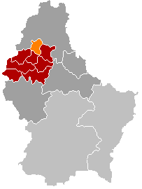
| Popis |
English: Map of Eschweiler municipality, valid up to 1 January 2015. Own edit of Kanton WiltzLocatie.png |
| Dátum | 18. októbra 2005 (datum prvotního načtení souboru) |
| Zdroj | No machine-readable source provided. Own work assumed (based on copyright claims). |
| Autor | No machine-readable author provided. Markussep assumed (based on copyright claims). |
Licencovanie
| Ja, držiteľ autorských práv k tomuto dielu, uvoľňujem toto dielo ako voľné dielo (public domain). Toto platí celosvetovo. V niektorých krajinách to zákon neumožňuje; v tom prípade: Udeľujem komukoľvek právo používať toto dielo na ľubovoľné účely, bez akýchkoľvek podmienok ak také podmienky nevyžaduje zákon. |
História súboru
Po kliknutí na dátum/čas uvidíte ako súbor vyzeral vtedy.
| Dátum/Čas | Náhľad | Rozmery | Používateľ | Komentár | |
|---|---|---|---|---|---|
| aktuálna | 23:06, 27. október 2011 | | 203 × 270 (3 KB) | Les Meloures | change map after creation of new municipalities in Luxembourg |
| 19:45, 3. máj 2006 |  | 203 × 270 (4 KB) | Markussep | ||
| 19:34, 18. október 2005 |  | 203 × 270 (4 KB) | Markussep | own edit of Image:Kanton WiltzLocatie.png Category:Maps of municipalities of Luxembourg |
Použitie súboru
Na tento súbor odkazuje nasledujúca stránka:
Globálne využitie súborov
Nasledovné ďalšie wiki používajú tento súbor:
- Použitie na als.wikipedia.org
- Použitie na ca.wikipedia.org
- Použitie na da.wikipedia.org
- Použitie na en.wikipedia.org
- Použitie na fa.wikipedia.org
- Použitie na fr.wikipedia.org
- Použitie na it.wikipedia.org
- Použitie na lb.wikipedia.org
- Použitie na nl.wikipedia.org
- Použitie na no.wikipedia.org
- Použitie na pl.wikipedia.org
- Použitie na pt.wikipedia.org
- Použitie na ru.wikipedia.org
- Použitie na tr.wikipedia.org
- Použitie na uk.wikipedia.org
- Použitie na www.wikidata.org
- Použitie na zh-min-nan.wikipedia.org
- Použitie na zh.wikipedia.org