Súbor:Map of the Viceroyalty of Peru.svg

Veľkosť tohoto PNG náhľadu tohoto SVG súboru: 800 × 407 pixelov. Iné rozlíšenia: 320 × 163 pixelov | 640 × 325 pixelov | 1 024 × 520 pixelov | 1 280 × 650 pixelov | 2 560 × 1 301 pixelov | 3 121 × 1 586 pixelov .
Pôvodný súbor (SVG súbor, 3 121 × 1 586 pixelov, veľkosť súboru: 1,67 MB)
Zhrnutie
| Popis |
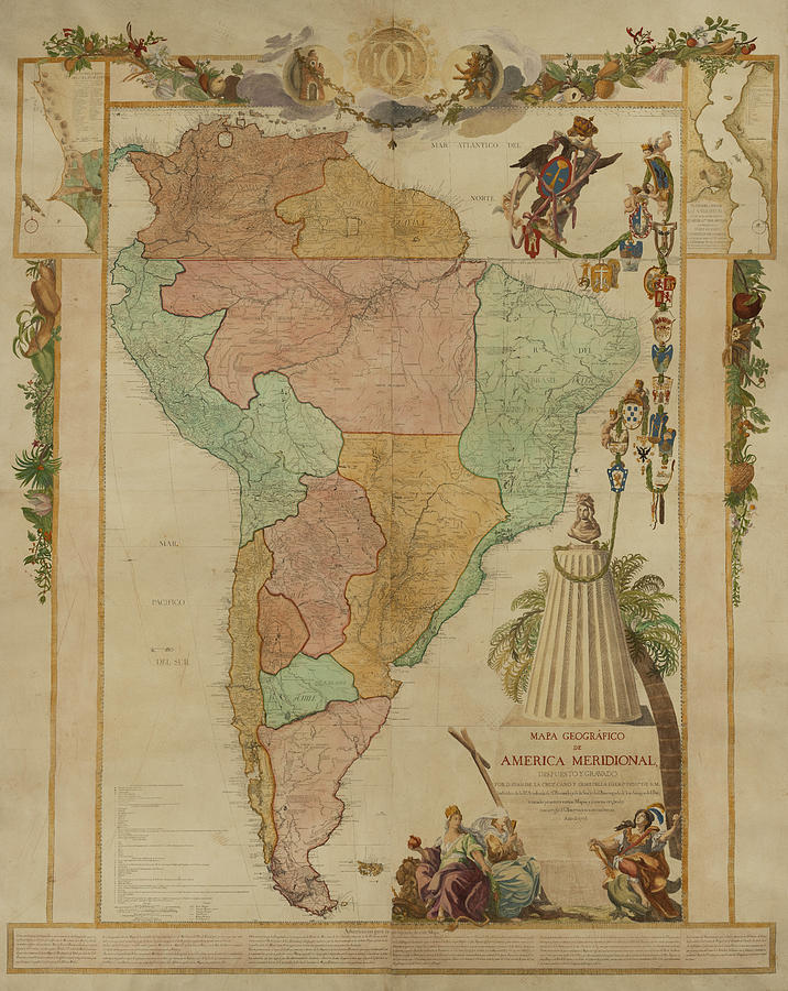
Español: Mapa de ubicación del Virreinato del Perú (territorio inicial (1542) y final (1810) de iure) English: Locator map of the Viceroyalty of Peru (initial (1542) and final (1810) de jure territory). |
| Dátum | (UTC) |
| Zdroj |
|
| Autor | Shadowxfox |
.jpg)
Licencovanie
Tento súbor podlieha licencii Creative Commons Attribution-Share Alike 3.0 Unported
- Môžete slobodne:
- zdieľať – kopírovať, šíriť a prenášať dielo
- meniť ho – upravovať dielo
- Za nasledovných podmienok:
- uvedenie autorov – Musíte spomenúť autorov (jednotlivo alebo kolektívne), poskytnúť odkaz na licenciu a uviesť, či ste niečo zmenili. Môžete to urobiť ľubovoľným primeraným spôsobom, ale nie spôsobom naznačujúcim, že poskytovateľ licencie podporuje vás alebo vaše použitie diela.
- meniť za rovnakých podmienok – Ak toto dielo zmeníte, prevediete do inej formy alebo použijete ako základ iného diela, musíte výsledok šíriť pod rovnakou alebo kompatibilnou licenciou ako originál.
História súboru
Po kliknutí na dátum/čas uvidíte ako súbor vyzeral vtedy.
| Dátum/Čas | Náhľad | Rozmery | Používateľ | Komentár | |
|---|---|---|---|---|---|
| aktuálna | 16:47, 22. január 2024 | | 3 121 × 1 586 (1,67 MB) | Janitoalevic | Reverted to version as of 16:41, 18 January 2024 (UTC) En el mapa se muestran territorios de iure, la Amazonía por ejemplo, no se ocupó de facto, mismo caso con la Patagonia. |
| 19:41, 20. január 2024 |  | 3 121 × 1 586 (1,67 MB) | ULIFOX 3XX | Reverted to version as of 04:37, 5 January 2024 (UTC) Si no fue 'De facto' parte del territorio de la Capitanía General de Chile, porque en la practica no fue parte del Virreinato | |
| 16:41, 18. január 2024 |  | 3 121 × 1 586 (1,67 MB) | Janitoalevic | Reverted to version as of 01:41, 16 August 2023 (UTC) La Patagonia pertenecía de iure a a Chile y por ende virreinato del Perú. También los territorios de la Amazonía se encontraban bajo dominio de iure. | |
| 04:37, 5. január 2024 |  | 3 121 × 1 586 (1,67 MB) | ULIFOX 3XX | El Virreinato del Perú nunca tuvo la patagonia como territorio inicial. La Patagonia fue adquirida por Chile y Argentina (ya independizados) despues de 1880 | |
| 01:41, 16. august 2023 |  | 3 121 × 1 586 (1,67 MB) | Janitoalevic | En verde claro van los territorios que dejaron de ser del virreinato del Perú con las reformas borbónicas. | |
| 09:24, 4. máj 2023 |  | 3 121 × 1 586 (1,67 MB) | Durero | Los territorios que el virreinato nunca controló de forma efectivo van en verde claro | |
| 16:04, 14. február 2023 |  | 3 121 × 1 586 (1,67 MB) | Janitoalevic | Reverted to version as of 03:20, 29 December 2022 (UTC) | |
| 16:08, 19. január 2023 |  | 3 121 × 1 586 (1,67 MB) | Durero | Reverted to version as of 21:41, 12 December 2022 (UTC) | |
| 03:20, 29. december 2022 |  | 3 121 × 1 586 (1,67 MB) | Janitoalevic | Fuente: 1 2 [https://es.wikipedia.org/wiki/Fronteras_de_Chile#cite_note-HistoriaDeLasFronteras-13] | |
| 21:41, 12. december 2022 |  | 3 121 × 1 586 (1,67 MB) | Echando una mano | Reverted to version as of 12:20, 7 September 2022 (UTC): no se corresponde con la realidad. |
.jpg)
Použitie súboru
Na tento súbor odkazuje nasledujúca stránka:
Globálne využitie súborov
Nasledovné ďalšie wiki používajú tento súbor:
- Použitie na ar.wikipedia.org
- Použitie na ast.wikipedia.org
- Použitie na be.wikipedia.org
- Použitie na bg.wikipedia.org
- Použitie na ca.wikipedia.org
- Použitie na cs.wikipedia.org
- Použitie na cy.wikipedia.org
- Použitie na da.wikipedia.org
- Použitie na en.wikipedia.org
- Použitie na es.wikipedia.org
- Historia universal
- Virreinato del Perú
- Imperio español
- Conquista del Imperio incaico
- Hipólito Francisco de Villegas
- Tacna, Arica y Tarapacá hasta 1929
- Organización territorial del virreinato del Perú
- Pedro Álvarez Holguín
- Miguel Mariano de Villegas
- Juan de Lacoizqueta
- Manuel Maciel y Cabral de Alpoin
- Použitie na et.wikipedia.org
- Použitie na eu.wikipedia.org
- Použitie na fa.wikipedia.org
- Použitie na fr.wikipedia.org
- Použitie na he.wikipedia.org
- Použitie na ia.wikipedia.org
- Použitie na id.wikipedia.org
- Použitie na it.wikipedia.org
- Použitie na ja.wikipedia.org
- Použitie na ka.wikipedia.org
- Použitie na ko.wikipedia.org
- Použitie na la.wikipedia.org
- Použitie na lt.wikipedia.org
- Použitie na mk.wikipedia.org
- Použitie na mt.wikipedia.org
- Použitie na nl.wikipedia.org
- Použitie na no.wikipedia.org
- Použitie na pl.wikipedia.org
- Použitie na pt.wikipedia.org
- Použitie na qu.wikipedia.org
- Použitie na ro.wikipedia.org
- Použitie na ru.wikipedia.org
- Použitie na simple.wikipedia.org
- Použitie na sr.wikipedia.org
Zobraziť ďalšie globálne použitie tohto súboru.