Súbor:PIA22878-Mars-InSightLander-FinalLocation-20181213.jpg

Pôvodný súbor (1 650 × 1 275 pixelov, veľkosť súboru: 1,38 MB, MIME typ: image/jpeg)
Zhrnutie
| Popis |
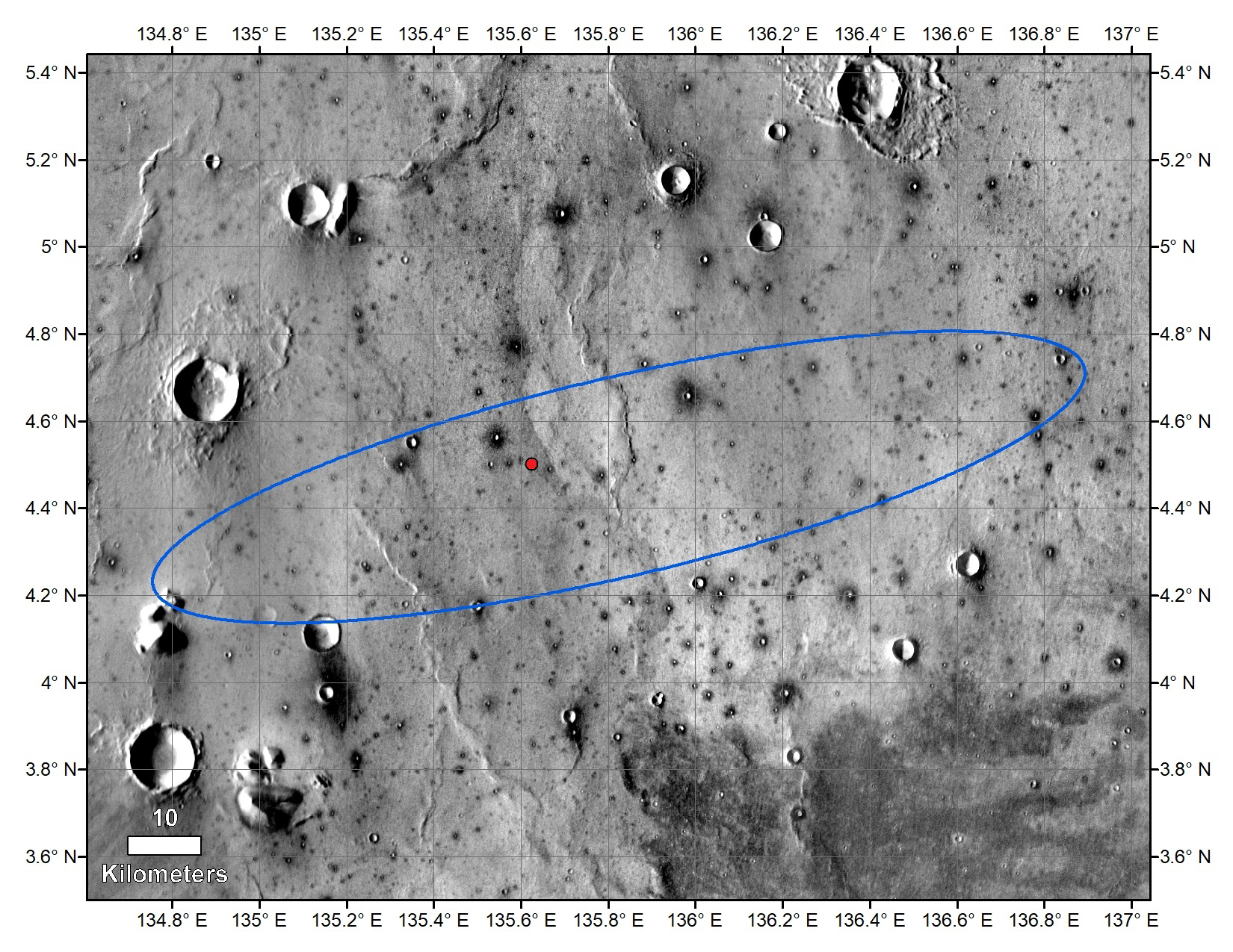
English: PIA22878: InSight's Final Location on Mars
https://photojournal.jpl.nasa.gov/catalog/PIA22878 The red dot marks the final landing location of NASA's InSight lander in this annotated image of the surface of Mars, taken by the THEMIS camera on NASA's 2001 Mars Odyssey orbiter in 2015. A version with latitude and longitude is also available. The landing ellipse on this map covers an area within which the spacecraft had about a 99 percent chance of landing when targeted for the center of the ellipse. It is about 81 miles (130 kilometers) long, generally west to east, and about 17 miles (27 kilometers) wide. The base map is a mosaic of daytime thermal images from the Thermal Emission Imaging System (THEMIS) on NASA's Mars Odyssey orbiter. THEMIS was developed and is operated by Arizona State University, Tempe. JPL manages InSight for NASA's Science Mission Directorate. InSight is part of NASA's Discovery Program, managed by the agency's Marshall Space Flight Center in Huntsville, Alabama. Lockheed Martin Space in Denver built the InSight spacecraft, including its cruise stage and lander, and supports spacecraft operations for the mission. A number of European partners, including France's Centre National d'Études Spatiales (CNES) and the German Aerospace Center (DLR), are supporting the InSight mission. CNES and the Institut de Physique du Globe de Paris (IPGP) provided the Seismic Experiment for Interior Structure (SEIS) instrument, with significant contributions from the Max Planck Institute for Solar System Research (MPS) in Germany, the Swiss Institute of Technology (ETH) in Switzerland, Imperial College and Oxford University in the United Kingdom, and JPL. DLR provided the Heat Flow and Physical Properties Package (HP3) instrument, with significant contributions from the Space Research Center (CBK) of the Polish Academy of Sciences and Astronika in Poland. Spain's Centro de Astrobiología (CAB) supplied the wind sensors. The University of Arizona, Tucson, operates HiRISE, which was built by Ball Aerospace & Technologies Corp., Boulder, Colorado. NASA's Jet Propulsion Laboratory, a division of Caltech in Pasadena, California, manages the Mars Reconnaissance Orbiter Project for NASA's Science Mission Directorate, Washington. |
| Dátum | |
| Zdroj | https://photojournal.jpl.nasa.gov/figures/PIA22878_fig1.jpg |
| Autor | NASA/JPL-Caltech/University of Arizona |
Tento mediální soubor byl katalogizován v Jet Propulsion Laboratory amerického Národního úřadu pro letectví a kosmonautiku (NASA)pod Photo ID: PIA22878. Toto oznámení nepopisuje autorskoprávní status tohoto souboru. Stále je vyžadován běžný popisek licence. Další informace najdete na Commons:Licencování. Jiné jazyky:
|
Licencovanie
| This file is in the public domain in the United States because it was solely created by NASA. NASA copyright policy states that "NASA material is not protected by copyright unless noted". (See Template:PD-USGov, NASA copyright policy page or JPL Image Use Policy.) | ||
 |
Warnings:
|
História súboru
Po kliknutí na dátum/čas uvidíte ako súbor vyzeral vtedy.
| Dátum/Čas | Náhľad | Rozmery | Používateľ | Komentár | |
|---|---|---|---|---|---|
| aktuálna | 15:22, 14. december 2018 | | 1 650 × 1 275 (1,38 MB) | Drbogdan | User created page with UploadWizard |
Použitie súboru
Na tento súbor odkazuje nasledujúca stránka:
Globálne využitie súborov
Nasledovné ďalšie wiki používajú tento súbor:
- Použitie na en.wikipedia.org