Súbor:Paneuropetransport.png

Veľkosť tohto náhľadu: 492 × 600 pixelov. Iné rozlíšenia: 197 × 240 pixelov | 394 × 480 pixelov | 773 × 942 pixelov .
Pôvodný súbor (773 × 942 pixelov, veľkosť súboru: 32 KB, MIME typ: image/png)
Zhrnutie

|
K tomuto obrázku existuje vektorová verzia (v SVG).
Ak je lepšia, používajte radšej tú. File:Paneuropetransport.png → File:Pan-European corridors.svg
Podrobnejšie informácie o vektorovej grafike nájdete na stránke Commons:Transition to SVG. Taktiež si môžete prečítať informácie o podpore formátu SVG v MediaWiki. |
 |
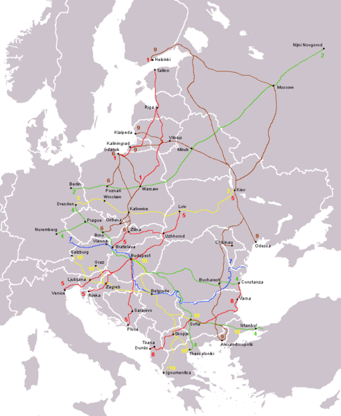
The ten Pan-European transport corridors.
Created by User:Albinfo using User:wiki-vr's blank map.
derivative works
Derivative works of this file: Pan-European corridors.svg
Licencovanie
| Ja, držiteľ autorských práv k tomuto dielu, uvoľňujem toto dielo ako voľné dielo (public domain). Toto platí celosvetovo. V niektorých krajinách to zákon neumožňuje; v tom prípade: Udeľujem komukoľvek právo používať toto dielo na ľubovoľné účely, bez akýchkoľvek podmienok ak také podmienky nevyžaduje zákon. |
História súboru
Po kliknutí na dátum/čas uvidíte ako súbor vyzeral vtedy.
| Dátum/Čas | Náhľad | Rozmery | Používateľ | Komentár | |
|---|---|---|---|---|---|
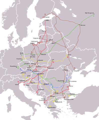
| aktuálna | 13:15, 14. august 2013 | | 773 × 942 (32 KB) | Spiridon Ion Cepleanu | Little rectifications around low-Danube |
| 08:05, 18. október 2007 |  | 773 × 942 (44 KB) | Hoshie | added Montenegro. Under same lic. as before. | |
| 23:11, 12. december 2006 |  | 773 × 942 (37 KB) | Albinfo | Fixed several errors and updated corrections in the original file - sorry for all the misleadings | |
| 20:06, 5. december 2006 |  | 773 × 941 (33 KB) | Geo-Loge~commonswiki | Ostrava => Brno, Ostrava added, Wroclaw and Krakow added | |
| 17:12, 24. jún 2006 |  | 773 × 941 (28 KB) | Joy | Fixed confusion between Lviv and Uzhorod. | |
| 22:42, 30. december 2005 |  | 773 × 941 (36 KB) | Albinfo | The ten Pan-European transport corridors. Created by User:Albinfo using User:wiki-vr's blank map. |
Použitie súboru
Žiadne stránky neobsahujú odkazy na tento súbor.
Globálne využitie súborov
Nasledovné ďalšie wiki používajú tento súbor:
- Použitie na be.wikipedia.org
- Použitie na cs.wikipedia.org
- Použitie na de.wikipedia.org
- Použitie na eo.wikipedia.org
- Použitie na es.wikipedia.org
- Použitie na fr.wikipedia.org
- Použitie na sr.wikipedia.org
- Použitie na sv.wikipedia.org