Súbor:Reliefkarte Zürich blank.png

Veľkosť tohto náhľadu: 585 × 599 pixelov. Iné rozlíšenia: 234 × 240 pixelov | 469 × 480 pixelov | 750 × 768 pixelov | 1 000 × 1 024 pixelov | 1 810 × 1 854 pixelov .
Pôvodný súbor (1 810 × 1 854 pixelov, veľkosť súboru: 2,37 MB, MIME typ: image/png)
| Popis |
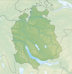
Deutsch: Reliefkarte des Kantons Zürich
Topographischer Hintergrund: NASA Shuttle Radar Topography Mission (public domain). SRTM3 v.2. |
||||||||
| Dátum | |||||||||
| Zdroj | Vlastné dielo | ||||||||
| Autor | Tschubby | ||||||||
| Povolenie (Využívanie tohto súboru) |
Ja, držiteľ autorských práv k tomuto dielu ho týmto zverejňujem za podmienok nasledovných licencií:
Tento súbor je licencovaný za podmienok Creative Commons Attribution-Share Alike 2.5 Generic, 2.0 Generic a 1.0 Generic.
Môžete si zvoliť ľubovolnú z týchto licencií. |
||||||||
| Ďalšie verzie |
 |

História súboru
Po kliknutí na dátum/čas uvidíte ako súbor vyzeral vtedy.
| Dátum/Čas | Náhľad | Rozmery | Používateľ | Komentár | |
|---|---|---|---|---|---|
| aktuálna | 09:36, 13. jún 2014 | | 1 810 × 1 854 (2,37 MB) | Tschubby | {{Information |Description= |Source= |Date= |Author= |Permission= |other_versions= }} |
| 12:54, 6. december 2013 |  | 1 813 × 1 855 (3,35 MB) | Tschubby | {{Information |Description= {{de| Reliefkarte des Kantons Zürich}} Topographischer Hintergrund: [http://www2.jpl.nasa.gov/srtm NASA Shuttle Radar Topography Mission] (public domain). SRTM3 v.2. |Source={{own}} |Date= 2013-12-06 |Author= [[:de:User:Tsc... |
Použitie súboru
Žiadne stránky neobsahujú odkazy na tento súbor.
Globálne využitie súborov
Nasledovné ďalšie wiki používajú tento súbor:
- Použitie na als.wikipedia.org
- Použitie na bg.wikipedia.org
- Použitie na de.wikipedia.org
- Lägern
- Uetliberg
- Forch
- Pfannenstiel (Zürich)
- Bahnhof Langholz
- Wildpark Langenberg
- Albispass
- Albis
- Zimmerberg
- Bachtel
- Ruine Alt-Landenberg
- Ruine Tössegg
- Ruine Alt-Wildberg
- Schnabelburg (Albis)
- Ruine Glanzenberg
- Ruine Liebenberg (Tösstal)
- Ruine Alt-Lägern
- Ruine Breitenlandenberg
- Ruine Freienstein
- Ruine Hohenlandenberg
- Ruine Schauenberg
- Ruine Sünikon
- Fernsehturm Uetliberg
- Türlersee
- Park im Grüene
- Hörnli (Berg)
- Zürichberg
- Irchel
- Zimmerberg-Basistunnel
- Buchenegg
- Hirzel (Pass)
- Islisbergtunnel
- Kirche Enge
- Burg Sellenbüren
- Burg Baldern
- Sternenweiher
- Burg Uetliburg
- Tössstock
Zobraziť ďalšie globálne použitie tohto súboru.