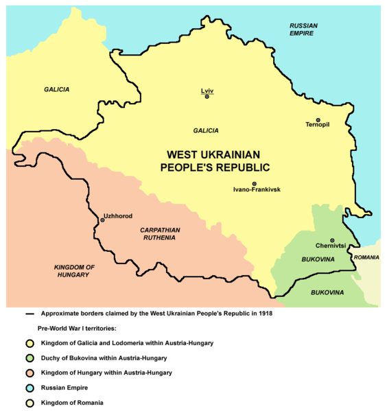
Súbor:West ukraine.png

Veľkosť tohto náhľadu: 564 × 599 pixelov. Iné rozlíšenia: 226 × 240 pixelov | 452 × 480 pixelov | 874 × 929 pixelov .
Pôvodný súbor (874 × 929 pixelov, veľkosť súboru: 62 KB, MIME typ: image/png)
História súboru
Po kliknutí na dátum/čas uvidíte ako súbor vyzeral vtedy.
| Dátum/Čas | Náhľad | Rozmery | Používateľ | Komentár | |
|---|---|---|---|---|---|
| aktuálna | 18:41, 22. marec 2012 |  | 874 × 929 (62 KB) | PANONIAN | Reverted to version as of 19:21, 21 March 2012 - please stop this, read "References" section, map is referenced |
| 15:36, 22. marec 2012 |  | 564 × 599 (94 KB) | Spiridon Ion Cepleanu | OK Pannonian, I taked off the Soviet border (1940 in Bukovina, 1945 in Galicia & Transcarpathia) and drawed only the WUPR claims of 1918-19 since Meyer's Atlas. The soviet border is generally not in concordance with the WUPR claims and included new tow... | |
| 19:21, 21. marec 2012 |  | 874 × 929 (62 KB) | PANONIAN | Reverted to version as of 16:35, 21 April 2011 - this is substantial difference, please upload your file version under different name | |
| 16:12, 21. marec 2012 |  | 564 × 599 (108 KB) | Spiridon Ion Cepleanu | Difference between 1918 claims and 1945 border, since Edgar Lehmann, Meyers Handatlas, Bibliographisches Institut Leipzig, 1927, and all actual atlases. | |
| 16:35, 21. apríl 2011 |  | 874 × 929 (62 KB) | PANONIAN | improved version | |
| 15:50, 29. december 2006 |  | 627 × 542 (58 KB) | Electionworld | {{ew|en|PANONIAN}} Map of the areas claimed by the West Ukrainian People's Republic (self made) {{PD-self}} Category:Maps of the history of Ukraine |
Použitie súboru
Žiadne stránky neobsahujú odkazy na tento súbor.
Globálne využitie súborov
Nasledovné ďalšie wiki používajú tento súbor:
- Použitie na ar.wikipedia.org
- Použitie na bg.wikipedia.org
- Použitie na ca.wikipedia.org
- Použitie na cs.wikipedia.org
- Použitie na eo.wikipedia.org
- Použitie na et.wikipedia.org
- Použitie na fi.wikipedia.org
- Použitie na hr.wikipedia.org
- Použitie na hu.wikipedia.org
- Použitie na it.wikipedia.org
- Použitie na ja.wikipedia.org
- Použitie na lt.wikipedia.org
- Použitie na mk.wikipedia.org
- Použitie na no.wikipedia.org
- Použitie na pam.wikipedia.org
- Použitie na pl.wikipedia.org
- Použitie na pt.wikipedia.org
- Použitie na ro.wikipedia.org
- Použitie na rue.wikipedia.org
- Použitie na ru.wikipedia.org
- Použitie na sh.wikipedia.org
- Použitie na simple.wikipedia.org
- Použitie na sr.wikipedia.org
- Použitie na uk.wikipedia.org
- Použitie na vi.wikipedia.org
