Súbor:Census Regions and Divisions.PNG
Veľkosť tohto náhľadu: 788 × 600 pixelov. Iné rozlíšenia: 315 × 240 pixelov | 631 × 480 pixelov | 909 × 692 pixelov .
Pôvodný súbor (909 × 692 pixelov, veľkosť súboru: 92 KB, MIME typ: image/png)
Zhrnutie

|
This map has been uploaded by Electionworld from en.wikipedia.org to enable the |
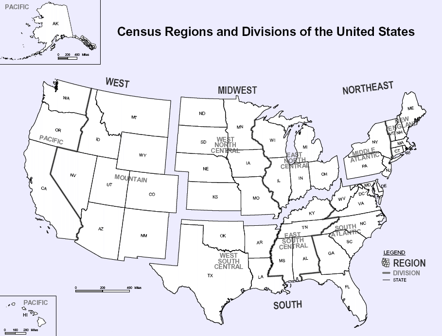
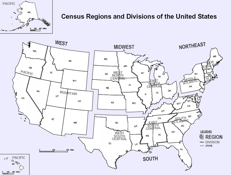
Map of U.S. Census Regions and Divisions. This map shows the four official US Census Regions, and the nine official Divisions within those Regions. See also: Image:US Census regional map.gif.
Licencovanie
Toto dílo je ve Spojených státech volným dílem, protože jde o dílo úřadů americké federální vlády podle ustanovení Hlavy 17, Kapitoly 1, Sekce 105 amerického právního řádu. Viz Autorské právo.
Upozornění: uvedené se vztahuje pouze na díla úřadů federální vlády, nikoliv na úřady jednotlivých států, okresů, či nižších územně správních jednotek.
|
 | |
| Tento súbor bol identifikovaný, že nemá žiadne známe obmedzenia vyplývajúce z autorského zákona vrátane všetkých súvisiacich a susedných práv. | ||

|
K tomuto obrázku existuje vektorová verzia (v SVG).
Ak je lepšia, používajte radšej tú. File:Census Regions and Divisions.PNG → File:Census Regions and Division of the United States.svg
Podrobnejšie informácie o vektorovej grafike nájdete na stránke Commons:Transition to SVG. Taktiež si môžete prečítať informácie o podpore formátu SVG v MediaWiki. |
 |
História súboru
Po kliknutí na dátum/čas uvidíte ako súbor vyzeral vtedy.
| Dátum/Čas | Náhľad | Rozmery | Používateľ | Komentár | |
|---|---|---|---|---|---|
| aktuálna | 11:56, 9. november 2023 | | 909 × 692 (92 KB) | Harold | Reverted to version as of 19:46, 13 June 2010 (UTC), COM:OW |
| 22:08, 3. september 2020 |  | 2 200 × 1 700 (103 KB) | ACupOfCoffee | Census regions were changed in 2013. | |
| 19:46, 13. jún 2010 |  | 909 × 692 (92 KB) | Ras67 | cropped, wm removed | |
| 22:11, 29. november 2006 |  | 916 × 699 (107 KB) | Electionworld | {{ew|en|NThurston}} Map of U.S. Census Regions and Divisions. == Licensing == {{PD-USGov}} Category:Maps of the United States |
Použitie súboru
Na tento súbor odkazujú nasledujúce 2 stránky:
Globálne využitie súborov
Nasledovné ďalšie wiki používajú tento súbor:
- Použitie na bn.wikipedia.org
- Použitie na ca.wikipedia.org
- Použitie na de.wikipedia.org
- Použitie na en.wikipedia.org
- Použitie na eo.wikipedia.org
- Použitie na gl.wikipedia.org
- Použitie na it.wikipedia.org
- Použitie na ja.wikipedia.org
- Použitie na ko.wikipedia.org
- Použitie na nn.wikipedia.org
- Použitie na ro.wikipedia.org
- Použitie na simple.wikipedia.org
- Použitie na tr.wikipedia.org
- Použitie na vec.wikipedia.org
- Použitie na vi.wikipedia.org