Súbor:Ionian Revolt Campaign Map-en.svg

Veľkosť tohoto PNG náhľadu tohoto SVG súboru: 454 × 599 pixelov. Iné rozlíšenia: 182 × 240 pixelov | 364 × 480 pixelov | 582 × 768 pixelov | 776 × 1 024 pixelov | 1 552 × 2 048 pixelov | 1 330 × 1 755 pixelov .
Pôvodný súbor (SVG súbor, 1 330 × 1 755 pixelov, veľkosť súboru: 1 007 KB)
| Popis |
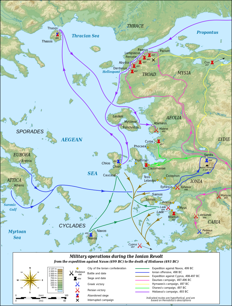
English: Map in English of the military operations during the Ionian Revolt which will lead to the Greco–Persian Wars. Notes: *The background map is a raster image embedded in the SVG file. *The routes shown are hypothetical, based on Herodotus's descriptions. Français : Carte en anglais des opérations militaires durant la révolte de l'Ionie qui va déclencher les Guerres médiques. Notes : *Le fond de carte est une image bitmap embarquée dans le fichier SVG. *Le tracé des routes suivies est figuratif et réalisé d'après les indications données par Hérodote. UTM projection – WGS84 datum Scale: 1:1,400,000 (precision: 350 m) |
| Dátum | (UTC) |
| Zdroj |
|
| Autor |
|
| Ďalšie verzie |
Derivative works of this file: Ionian Revolt Campaign Map-el.svg
|


| Toto je upravený obrázek, což znamená, že byl oproti původní verzi digitálně změněn. Úpravy: Translated to English. Původní verzi je možné zhlédnout zde: Ionian Revolt Campaign Map-fr.svg. Úpravy provedl MinisterForBadTimes.
|
Ja, držiteľ autorských práv k tomuto dielu ho týmto zverejňujem za podmienok nasledovných licencií:
Tento súbor podlieha licencii Creative Commons Attribution-Share Alike 3.0 Unported
- Môžete slobodne:
- zdieľať – kopírovať, šíriť a prenášať dielo
- meniť ho – upravovať dielo
- Za nasledovných podmienok:
- uvedenie autorov – Musíte spomenúť autorov (jednotlivo alebo kolektívne), poskytnúť odkaz na licenciu a uviesť, či ste niečo zmenili. Môžete to urobiť ľubovoľným primeraným spôsobom, ale nie spôsobom naznačujúcim, že poskytovateľ licencie podporuje vás alebo vaše použitie diela.
- meniť za rovnakých podmienok – Ak toto dielo zmeníte, prevediete do inej formy alebo použijete ako základ iného diela, musíte výsledok šíriť pod rovnakou alebo kompatibilnou licenciou ako originál.

|
Bolo udelené povolenie kopírovať, širiť a/alebo meniť tento dokument za podmienok GNU Free Documentation License, verzie 1.2 alebo ktorejkoľvek neskoršej verzie publikovanej Free Software Foundation; bez Nemenných častí, bez Textov na prednej obálke a bez Textov na zadnej obálke. Kópia tejto licencie je zahrnutá v časti nazvanej GNU Free Documentation License. |
Môžete si zvoliť ľubovolnú z týchto licencií.
Pôvodný záznam nahrávaní
This image is a derivative work of the following images:
- File:Ionian_Revolt_Campaign_Map-fr.svg licensed with Cc-by-sa-3.0, GFDL
- 2009-06-27T12:58:50Z Sting 1330x1755 (1054965 Bytes) Oups! (some of the corrections haven't been saved)
- 2009-06-27T12:36:18Z Sting 1330x1755 (1053759 Bytes) Correction of the Antic shoreline around Miletus and Ephesus ; more precise position of some polis
- 2009-06-26T19:10:39Z Sting 1330x1755 (1054137 Bytes) == Summary == {{Information| |Description={{en|Map in French of the military operations during the [[:en:Ionian Revolt|Ionian Revolt]] which will lead to the [[:en:Greco–Persian Wars|Greco–Persian Wars]].''Notes:'' *''The
Uploaded with derivativeFX
História súboru
Po kliknutí na dátum/čas uvidíte ako súbor vyzeral vtedy.
| Dátum/Čas | Náhľad | Rozmery | Používateľ | Komentár | |
|---|---|---|---|---|---|
| aktuálna | 15:20, 23. jún 2011 | | 1 330 × 1 755 (1 007 KB) | AnonMoos | "Abandoned" spelling |
| 19:51, 15. január 2010 |  | 1 330 × 1 755 (1 007 KB) | MinisterForBadTimes | {{Information |Description={{en|Map in French of the military operations during the Ionian Revolt which will lead to the Greco–Persian Wars.<br/>''Notes:''<br/> *''The background map is a raster image e |
Použitie súboru
Na tento súbor odkazuje nasledujúca stránka:
Globálne využitie súborov
Nasledovné ďalšie wiki používajú tento súbor:
- Použitie na af.wikipedia.org
- Použitie na azb.wikipedia.org
- Použitie na bg.wikipedia.org
- Použitie na cs.wikipedia.org
- Použitie na de.wikipedia.org
- Použitie na en.wikipedia.org
- Použitie na et.wikipedia.org
- Použitie na eu.wikipedia.org
- Použitie na fa.wikipedia.org
- Použitie na he.wikipedia.org
- Použitie na hr.wikipedia.org
- Použitie na id.wikipedia.org
- Použitie na id.wikibooks.org
- Použitie na it.wikipedia.org
- Použitie na ja.wikipedia.org
- Použitie na nl.wikipedia.org
- Použitie na no.wikipedia.org
- Použitie na pl.wikipedia.org
- Použitie na sh.wikipedia.org
- Použitie na sr.wikipedia.org
- Použitie na ta.wikipedia.org
- Použitie na tr.wikipedia.org
- Použitie na vi.wikipedia.org