Súbor:Spain and Portugal.png

Veľkosť tohto náhľadu: 800 × 411 pixelov. Iné rozlíšenia: 320 × 164 pixelov | 640 × 329 pixelov | 1 024 × 526 pixelov | 1 500 × 771 pixelov .
Pôvodný súbor (1 500 × 771 pixelov, veľkosť súboru: 92 KB, MIME typ: image/png)
Zhrnutie

|
Tento obrázek (skupina map) by měl být vytvořen pomocí vektorové grafiky jako SVG soubor. To má několik výhod; podrobnosti najdete na stránce Commons:Media for cleanup. Je-li SVG verze tohoto obrázku již k dispozici, prosím nahrajte ji. Po nahrání nahraďte tuto šablonu šablonou {{Vector version available|jméno nového obrázku.svg}}.
|
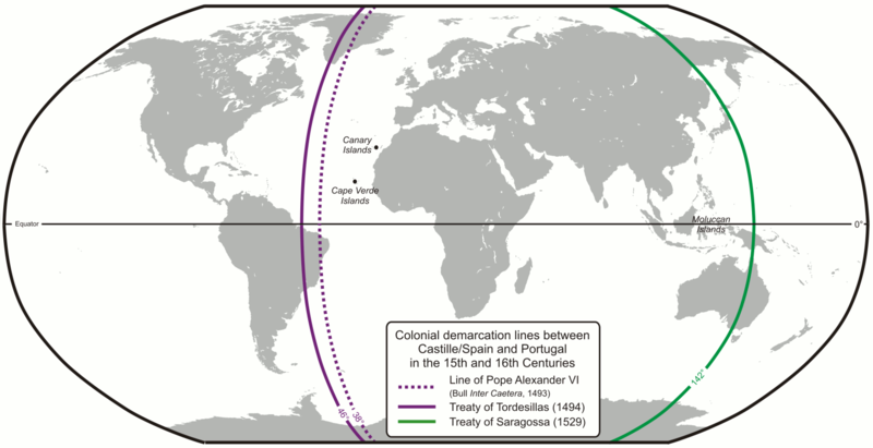
| Popis | Colonial demarcation lines between Castille/Spain and Portugal in the 15th and 16th Centuries. (Treaty of Tordesillas and Treaty of Saragossa) |
| Dátum | |
| Zdroj | Vlastné dielo |
| Autor | Lencer |
| Ďalšie verzie |
|


|
Tato mapa byla vytvořena nebo vylepšena v německé Kartenwerkstatt (Mapová laboratoř). Můžete také navrhnout mapy k vylepšení.
|
Licencovanie
The map has been created with the Generic Mapping Tools: https://www.generic-mapping-tools.org/ using one or more of these public-domain datasets for the relief:
|

|
Bolo udelené povolenie kopírovať, širiť a/alebo meniť tento dokument za podmienok GNU Free Documentation License, verzie 1.2 alebo ktorejkoľvek neskoršej verzie publikovanej Free Software Foundation; bez Nemenných častí, bez Textov na prednej obálke a bez Textov na zadnej obálke. Kópia tejto licencie je zahrnutá v časti nazvanej GNU Free Documentation License. |
| Tento súbor podlieha licencii Creative Commons Attribution-Share Alike 3.0 Unported | ||
| ||
| Táto šablóna licencie bola pridaná k tomuto súboru počas aktualizácie licencovania GFDL. |
História súboru
Po kliknutí na dátum/čas uvidíte ako súbor vyzeral vtedy.
| Dátum/Čas | Náhľad | Rozmery | Používateľ | Komentár | |
|---|---|---|---|---|---|
| aktuálna | 07:52, 16. február 2013 | | 1 500 × 771 (92 KB) | JohnnyMrNinja | indexed colors and increased compression |
| 09:10, 7. december 2007 |  | 1 500 × 771 (254 KB) | Lencer | {{Convert to SVG|map}} {{Information |Description= Karte der spanischen und portugiesischen Einflussbereiche nach den Verträgen von Tordesillas, Saragossa und [[:de:Vertrag von Alcaçovas|Alca |
Použitie súboru
Na tento súbor odkazujú nasledujúce 2 stránky:
Globálne využitie súborov
Nasledovné ďalšie wiki používajú tento súbor:
- Použitie na ar.wikipedia.org
- Použitie na ast.wikipedia.org
- Použitie na ca.wikipedia.org
- Použitie na cs.wikipedia.org
- Použitie na el.wikipedia.org
- Použitie na en.wikipedia.org
- 1529
- Treaty of Tordesillas
- Portuguese Empire
- Spanish Empire
- Age of Discovery
- Spanish Canadians
- Slavery in colonial Spanish America
- Portuguese maritime exploration
- Alexandre de Gusmão
- List of territorial claims and designations in Colorado
- Territorial evolution of California
- Treaty of Zaragoza
- User:Mcapdevila/LatMaps
- Použitie na en.wikivoyage.org
- Použitie na eo.wikipedia.org
- Použitie na es.wikipedia.org
- Použitie na et.wikipedia.org
- Použitie na fa.wikipedia.org
- Použitie na fi.wikipedia.org
- Použitie na fr.wikipedia.org
- Použitie na hy.wikipedia.org
- Použitie na id.wikipedia.org
- Použitie na it.wikipedia.org
Zobraziť ďalšie globálne použitie tohto súboru.